Aktogay | |
|---|---|
District | |
| Ақтоғай ауданы | |
.png.webp) Coat of arms | |
 | |
| Country | Kazakhstan |
| Region | Karaganda Region |
| Administrative center | Aktogay |
| Founded | 1928 |
| Government | |
| • Akim | Ruslan Kenzhebekov[1] |
| Area | |
| • Total | 20,000 sq mi (52,000 km2) |
| Population (2013)[2] | |
| • Total | 18,497 |
| Time zone | UTC+6 (East) |
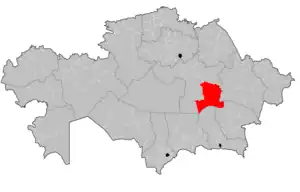
Aktogay District (Kazakh: Ақтоғай ауданы, Aqtoğai audany) is a district of Karaganda Region in central Kazakhstan. The administrative center of the district is the selo of Aktogay.[3] Population: 18,497 (2013 estimate);[2] 19,233 (2009 Census results);[4] 24,051 (1999 Census results).[4]
Geography
Aksoran, the highest point of the Kyzylarai massif of the Kazakh Uplands, is located in the district. The larger Kyzyltas range rises to the northwest of it.[5][6]
References
- ↑ "В Актогайском районе новый аким". inkaraganda.kz (in Russian). 2023-01-19.
- 1 2 "Население Республики Казахстан" (in Russian). Департамент социальной и демографической статистики. Retrieved 27 December 2013.
- ↑ "www.geonames.de Subdivisions of Kazakhstan in local languages". Archived from the original on 2016-03-03. Retrieved 2008-04-22.
- 1 2 "Население Республики Казахстан" [Population of the Republic of Kazakhstan] (in Russian). Департамент социальной и демографической статистики. Retrieved 8 December 2013.
- ↑ Google Earth
- ↑ "M-43 Topographic Chart (in Russian)". Retrieved 18 September 2022.
Capital: Karaganda | ||
| Districts | 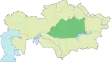 | |
| Major cities | ||
48°18′59″N 74°58′46″E / 48.3165°N 74.9794°E
This article is issued from Wikipedia. The text is licensed under Creative Commons - Attribution - Sharealike. Additional terms may apply for the media files.