Mueang Amnat Charoen
เมืองอำนาจเจริญ | |
|---|---|
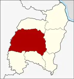 District location in Amnat Charoen province | |
| Coordinates: 15°51′30″N 104°37′46″E / 15.85833°N 104.62944°E | |
| Country | Thailand |
| Province | Amnat Charoen |
| Seat | Bung |
| Area | |
| • Total | 598.8 km2 (231.2 sq mi) |
| Population (2008) | |
| • Total | 128,992 |
| • Density | 216.2/km2 (560/sq mi) |
| Time zone | UTC+7 (ICT) |
| Postal code | 37000 |
| Geocode | 3701 |
Mueang Amnat Charoen (Thai: เมืองอำนาจเจริญ, pronounced [mɯ̄a̯ŋ ʔām.nâːt t͡ɕā.rɤ̄ːn]) is the capital district (amphoe mueang) of Amnat Charoen province, northeastern Thailand.
History
Originally Amnat Charoen was a mueang under Mueang Khemarat. In the Thesaphiban administrative reforms around 1900 it was reassigned to Ubon Ratchathani and converted into a district. It was later named Bung after the central tambon. In 1939 it was renamed Amnat Charoen.[1] In 1993 the new province Amnat Charoen was created, and the district was then renamed Mueang Amnat Charoen.[2]
Geography
Neighboring districts are (from the north clockwise): Senangkhanikhom, Pathum Ratchawongsa, Phana, Lue Amnat, and Hua Taphan of Amnat Charoen Province, and Pa Tio and Thai Charoen of Yasothon province.
Administration
The district is divided into 19 sub-districts (tambons), which are further subdivided into 213 villages (mubans). The town (thesaban mueang) Amnat Charoen covers parts of the tambon Bung. Nam Plik is a sub-district municipality (thesaban tambon) which covers parts of the same-named tambon. Na Wong, Na Mo Ma, and Na Yom are sub-district municipalities which cover the full same-named subdistricts. There are a further 16 tambon administrative organizations (TAO).
| No. | Name | Thai | Villages | Pop. |
|---|---|---|---|---|
| 1. | Bung | บุ่ง | 23 | 28,931 |
| 2. | Kai Kham | ไก่คำ | 13 | 8,111 |
| 3. | Na Chik | นาจิก | 8 | 4,187 |
| 4. | Pla Khao | ปลาค้าว | 12 | 5,656 |
| 5. | Lao Phruan | เหล่าพรวน | 8 | 3,915 |
| 6. | Sang Nok Tha | สร้างนกทา | 16 | 6,385 |
| 7. | Khuem Yai | คึมใหญ่ | 10 | 5,408 |
| 8. | Na Phue | นาผือ | 12 | 6,728 |
| 9. | Nam Plik | น้ำปลีก | 10 | 7,676 |
| 10. | Na Wang | นาวัง | 11 | 4,632 |
| 11. | Na Mo Ma | นาหมอม้า | 8 | 4,016 |
| 12. | Non Pho | โนนโพธิ์ | 11 | 6,537 |
| 13. | Non Nam Thaeng | โนนหนามแท่ง | 14 | 7,928 |
| 14. | Huai Rai | ห้วยไร่ | 10 | 5,413 |
| 15. | Nong Masaeo | หนองมะแซว | 13 | 4,236 |
| 16. | Kut Pla Duk | กุดปลาดุก | 12 | 5,870 |
| 17. | Don Moei | ดอนเมย | 5 | 2,822 |
| 18. | Na Yom | นายม | 8 | 5,072 |
| 19. | Na Tae | นาแต้ | 9 | 5,469 |
References
- ↑ พระราชกฤษฎีกาเปลี่ยนนามอำเภอ กิ่งอำเภอ และตำบลบางแห่ง พุทธศักราช ๒๔๘๒ (PDF). Royal Gazette (in Thai). 56 (ก): 354–364. April 17, 1939. Archived from the original (PDF) on February 19, 2009.
- ↑ พระราชบัญญัติตั้งจังหวัดอำนาจเจริญ พ.ศ. ๒๕๓๖ (PDF). Royal Gazette (in Thai). 110 (125 ก ฉบับพิเศษ): 4–6. 1993-09-02. Archived from the original (PDF) on June 4, 2012.
External links
 Amnat Charoen travel guide from Wikivoyage
- amphoe.com
Amnat Charoen (capital) | ||
| Districts (amphoe) |  | |
| Landmarks | ||