Athis-de-l'Orne | |
|---|---|
Part of Athis-Val-de-Rouvre | |
 | |
.svg.png.webp) Coat of arms | |
Location of Athis-de-l'Orne | |
 Athis-de-l'Orne  Athis-de-l'Orne | |
| Coordinates: 48°48′41″N 0°30′00″W / 48.8114°N 0.5°W | |
| Country | France |
| Region | Normandy |
| Department | Orne |
| Arrondissement | Argentan |
| Canton | Athis-de-l'Orne |
| Commune | Athis-Val-de-Rouvre |
| Area 1 | 32.47 km2 (12.54 sq mi) |
| Population (2019)[1] | 2,514 |
| • Density | 77/km2 (200/sq mi) |
| Time zone | UTC+01:00 (CET) |
| • Summer (DST) | UTC+02:00 (CEST) |
| Postal code | 61430 |
| Elevation | 102–268 m (335–879 ft) (avg. 231 m or 758 ft) |
| 1 French Land Register data, which excludes lakes, ponds, glaciers > 1 km2 (0.386 sq mi or 247 acres) and river estuaries. | |
Athis-de-l'Orne is a former commune in the Orne department in northwestern France. On 1 January 2016, it was merged into the new commune of Athis-Val-de-Rouvre.[2] The modifier "de l'Orne" was added to the name in 1968, to distinguish it from Athis in the departement of Marne and Athis-Mons in the departement of Essonne. The former commune is part of the area known as Suisse Normande.[3]
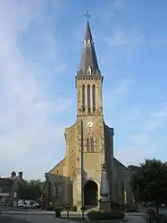
The rivers Vère and Lembron run through it. The church of St. Vigor dates from the 19th century.
Population
| Year | Pop. | ±% |
|---|---|---|
| 1962 | 2,047 | — |
| 1968 | 2,016 | −1.5% |
| 1975 | 2,202 | +9.2% |
| 1982 | 2,369 | +7.6% |
| 1990 | 2,395 | +1.1% |
| 1999 | 2,423 | +1.2% |
| 2006 | 2,579 | +6.4% |
| 2009 | 2,605 | +1.0% |
| 2012 | 2,577 | −1.1% |
| 2014 | 2,555 | −0.9% |
International relations
It has been twinned since 1980 with Bromyard in Herefordshire, England, and since 1986 with Schöppenstedt in Wolfenbüttel, Lower Saxony, Germany.
Heraldry
Arms of Athis-de-l'Orne |
The arms of Athis-de-l'Orne are blazoned : Argent, 2 chevrons between 3 ducks sable.
|
See also
References
- ↑ Téléchargement du fichier d'ensemble des populations légales en 2019, INSEE
- ↑ Arrêté préfectoral 16 December 2015 (in French)
- ↑ "Map of Suiss Normande" (PDF).
Wikimedia Commons has media related to Athis-de-l'Orne.
This article is issued from Wikipedia. The text is licensed under Creative Commons - Attribution - Sharealike. Additional terms may apply for the media files.