Bolívar Province | |
|---|---|
Province | |
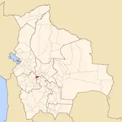 Location of Bolívar Province within Bolivia | |
 | |
| Coordinates: 18°0′S 67°5′W / 18.000°S 67.083°W | |
| Country | |
| Department | Cochabamba Department |
| Capital | Bolívar |
| Government | |
| • Mayor | Aniceto Cuti Felipe (2007) |
| Area | |
| • Total | 159 sq mi (413 km2) |
| Elevation | 13,000 ft (4,000 m) |
| Population (2001) | |
| • Total | 8,635 |
| • Density | 54/sq mi (20.9/km2) |
| • Ethnicities | Quechua |
| Time zone | UTC-4 (BOT) |
Bolívar Province is a province in the Bolivian department of Cochabamba. Its capital is the city of Bolívar, named after Simón Bolívar, a Venezuelan military and political leader.
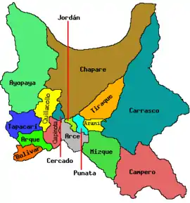
Subdivision
The province is not further subdivided into municipalities. So Bolívar Municipality and Bolívar Province are identical. The province is divided into nine cantons.
| Canton | Inhabitants (2001) [1] | Seat |
|---|---|---|
| Bolívar Canton | 3,437 | Bolívar |
| Carpani Canton | 620 | Carpani |
| Comuna Canton | 413 | Comuna |
| Coyuma Canton | 541 | Coyuma |
| Challoma Canton | 242 | Challoma |
| Jorenko Canton or Villa Verde Canton | 665 | Jorenko |
| Vilacaya Canton | 632 | Vilacaya |
| Villa Victoria Canton | 904 | Villa Victoria |
| Yarbicoya Canton | 1,181 | Yarbicoya |
The people
The people are predominantly indigenous citizens of Quechuan descent.
| Ethnic group | Inhabitants (%) |
|---|---|
| Quechua | 91.6 |
| Aymara | 4.3 |
| Guaraní, Chiquitos, Moxos | 0.1 |
| Not indigenous | 4.0 |
| Other indigenous groups | 0.0 |
Ref.: obd.descentralizacion.gov.bo
Languages
The languages spoken in the Bolívar Province are mainly Quechua and Spanish.[2]
| Language | Inhabitants |
|---|---|
| Quechua | 7,747 |
| Aymara | 484 |
| Guaraní | 3 |
| Another native | 0 |
| Spanish | 3,010 |
| Foreign | 6 |
| Only native | 4,948 |
| Native and Spanish | 2,914 |
| Only Spanish | 96 |
See also
References
- ↑ www.ine.gob.bo Archived September 24, 2011, at the Wayback Machine
- ↑ obd.descentralizacion.gov.bo / Observatorio Bolivia Democrático Archived February 18, 2009, at the Wayback Machine (Spanish)
External links
Capital: Cochabamba | ||
| Provinces | | |
| Municipalities (and seats) |
| |
18°00′S 67°05′W / 18.000°S 67.083°W
This article is issued from Wikipedia. The text is licensed under Creative Commons - Attribution - Sharealike. Additional terms may apply for the media files.