Chŭngsan County
증산군 | |
|---|---|
| Korean transcription(s) | |
| • Chosŏn'gŭl | 증산군 |
| • Hancha | 甑山郡 |
| • McCune-Reischauer | Chŭngsan-gun |
| • Revised Romanization | Jeungsan-gun |
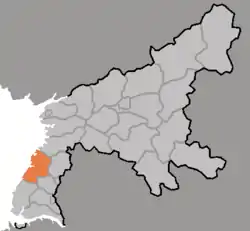 Map of South Pyongan showing the location of Chungsan | |
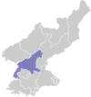
| Country | North Korea |
| Province | South P'yŏngan |
| Administrative divisions | 1 ŭp, 17 ri |
| Area | |
| • Total | 346.32 km2 (133.71 sq mi) |
| Population (2008[1]) | |
| • Total | 113,613 |
| • Density | 330/km2 (850/sq mi) |
Chŭngsan County is a kun (county) in South Pyongan Province, North Korea.
Re-education Camp No. 11, a large prison mostly for repatriated refugees, is located in the northwestern part of Chŭngsan County.
Administrative divisions
Chŭngsan county is divided into 1 ŭp (town) and 17 ri (villages):
|
|
Transportation
Chŭngsan county is served by the Namdong Branch of the Korean State Railway's P'yŏngnam Line.
References
- ↑ Korean Central Bureau of Statistics: 2008 Population Census Archived May 14, 2011, at the Wayback Machine (Population 2008, published in 2009)
External links
- (in English) Map of Pyongan provinces
- (in Korean) Detailed map
This article is issued from Wikipedia. The text is licensed under Creative Commons - Attribution - Sharealike. Additional terms may apply for the media files.