Dan Musa | |
|---|---|
LGA and town | |
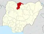
 Dan Musa Location in Nigeria | |
| Coordinates: 12°15′50″N 7°20′02″E / 12.26389°N 7.33389°E | |
| Country | |
| State | Katsina State |
| Established | 1996 |
| Government | |
| • Chairman | N.M.Danmusa |
| Area | |
| • Total | 792 km2 (306 sq mi) |
| Population (2006 census) | |
| • Total | 113,691 |
| Time zone | UTC+1 (WAT) |
| 3-digit postal code prefix | 821 |
| ISO 3166 code | NG.KT.DM |
Dan Musa is a Local Government Area in Katsina State, Nigeria. Its headquarters is in the town of Dan Musa.
It has an area of 792 km2 and a population of 113,691 at the 2006 census.
The postal code of the area is 821.[1]
Climate
With an average yearly temperature of 30.48°C, 50.92 inches of precipitation, and 53.9 rainy days, Dan Musa has a subtropical steppe climate.[2][3]
Dan Musa has varying seasonal temperatures; warm seasons last 1.6 months and have lows of 87°F; highs are up to 97°F and lows are at 75°F.[3]
References
- ↑ "Post Offices- with map of LGA". NIPOST. Archived from the original on October 7, 2009. Retrieved 2009-10-20.
- ↑ "Dan Musa, Katsina, NG Climate Zone, Monthly Averages, Historical Weather Data". tcktcktck.org. Retrieved 2023-08-29.
- 1 2 "Dan Musa Climate, Weather By Month, Average Temperature (Nigeria) - Weather Spark". weatherspark.com. Retrieved 2023-08-29.
State capital: Katsina | ||
| Topics |
|  |
| LGAs | ||
This article is issued from Wikipedia. The text is licensed under Creative Commons - Attribution - Sharealike. Additional terms may apply for the media files.