Hörgársveit | |
|---|---|
 Location of Hörgársveit | |
 Hörgársveit | |
| Coordinates: 65°27′26″N 18°49′40″W / 65.457247°N 18.8277973°W | |
| Country | Iceland |
| Region | Northeastern Region |
| Constituency | Northeast Constituency |
| Government | |
| • Manager | Snorri Finnlaugsson |
| Area | |
| • Total | 893 km2 (345 sq mi) |
| Population | |
| • Total | 802 |
| • Density | 0.63/km2 (1.6/sq mi) |
| Municipal number | 6515 |
| Website | horgarsveit |
.jpg.webp)
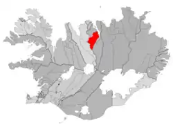
Hörgársveit (Icelandic pronunciation: [ˈhœrkˌaurˌsveiːt] ⓘ) is a municipality located in north-central Iceland, in Northeastern Region. Its seat is the village of Lónsbakki [ˈlounsˌpahcɪ].
History
The former municipality of Hörgárbyggð [ˈhœrkˌaurˌpɪɣθ] was formed on 1 January 2001 by the union of the municipalities of Skriða [ˈskrɪːða] (Skriðuhreppur [ˈskrɪːðʏˌr̥ɛhpʏr̥]), Öxnadalur [ˈœkstnaˌtaːlʏr̥] (Öxnadalshreppur [ˈœkstnaˌtalsˌr̥ɛhpʏr̥]) and Glæsibær [ˈklaiːsɪˌpaiːr̥] (Glæsibæjarhreppur [ˈklaiːsɪˌpaiːjar̥ˌr̥ɛhpʏr̥]). In 2010 Hörgárbyggð merged with the municipality of Arnarnes [ˈa(r)tnarˌnɛːs] (Arnarneshreppur [ˈa(r)tnarˌnɛsˌr̥ɛhpʏr̥] ) to form the current municipality of Hörgársveit.
Geography
Located on the Eyjafjörður, to the north of Akureyri, Hörgársveit is made up of several villages, principally Þelamörk [ˈθɛːlaˌmœr̥k], Lónsbakki (115 inhabitants) and Hjalteyri (37 inhabitants), the seat of the former municipality of Arnarnes.
References
External links
- Official website (in Icelandic)