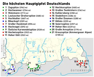
This is a list of the highest mountains in Germany. All of these mountains are located in the federal state of Bavaria. They lie within the Alps in the region known as the Eastern Alps and are part of the Northern Limestone Alps. The majority belong to the mountain ranges of the Wetterstein, Berchtesgaden Alps and Allgäu Alps.
Because the definition of a mountain is not universally agreed, a distinction is made between main summits and other peaks. Subsidiary summits or subpeaks are not counted. In the Alps a summit is classed as independent, according to the UIAA definition, if it has a prominence of 30 metres or more. In order for a peak to qualify as an independent mountain, however, it must have a prominence of at least 300 metres.[1] Based on this definition only the main summits of entire mountain massifs are counted. All elevations with a prominence below 30 metres are considered as subpeaks.[2]
By these definitions, the highest mountains in Germany are the Zugspitze (2,962 m), Hochwanner (2,746 m) and Watzmann (Middle Peak, 2,713 m). If all independent summits are counted, the Zugspitze is followed by the Schneefernerkopf (2,875 m) and the Middle Wetterspitze (2,747 m) in places two and three. Both are however, part of the Zugspitze massif and lie relatively close to the summit of the Zugspitze itself.
The highest mountain which lies entirely on German soil is the Watzmann with a height of 2,713 metres, followed by the Hochkalter (2,607 m), the Großer Daumen (2,280 m) and the Höfats (2,259 m). Likewise fully on German territory, but considerably less independent, are the Middle Höllentalspitze (2,742 m) and the Hochblassen (2,703 m).
A majority of the summits were verifiably climbed in the 19th century; the Watzmann and Hoher Göll for example as early as 1800. The Zugspitze was officially climbed for the first time in 1820. However, there are many peaks of which it is suspected had been climbed in earlier times by unknown climbers.
Because the borders of Germany have often changed during the course of the centuries, there were different "highest mountains" in the past. For example, during the time of the Holy Roman Empire up to 1806, the Ortler in present-day South Tyrol, at 3,905 m, was the highest German mountain. During the colonial period to 1918 Mount Kilimanjaro in the colony of German East Africa, at 5,895 m, was officially the highest mountain of the German Reich. During the Nazi era from 1938 to 1945 this title went to the Großglockner which, at 3,797 m, is today the highest mountain in Austria.
Key
- Ranking: The ranking of the peak within Germany in terms of height.
- Photograph: Photograph of the mountain.
- Peak: Name of the peak.
- Height: Height of the mountain in metres.
- Mountain range: Mountain range in which the mountain lies.
- Massif: (table 1) Gives the name of the massif to which the mountain belongs. If the massif is named after a linked main peak, the link is omitted here.
- Location: (table 2) DE = mountain lies entirely on German territory; DE/AT = mountain lies in the area of the border between Germany and Austria, but the peak at least is on German state territory.
- Isolation: The isolation describes the radius of the area which the mountain dominates. Given in kilometres including the reference point.
- Prominence: The prominence is the height difference between height of the summit and the highest point to which one must descend in order to climb a higher peak. Given in metres including the reference point.
- First climb: Name of the first climber and date. Empty field indicates that the first climber or the date is not known.
There may be differences in data from other sources. The tables use the tables of the German height reference system, based on height above Normalnull (~sea level) in Amsterdam, and data from the Bavarian Survey Office (Bayerischen Vermessungsverwaltung).[3]
The highest summits
Table 1 below shows the 30 highest independent summits in Germany. A summit or peak requires a prominence of over 30 metres in order to count as independent.
By clicking on the symbols at the head of the table the individual columns may be sorted.
| Ranking |
Photograph | Peak | Height (m) |
Mountain range | Massif | Isolation (km) |
Prominence (m) |
First climb |
|---|---|---|---|---|---|---|---|---|
| 1 | 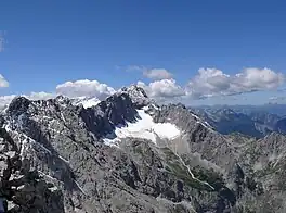 |
Zugspitze | 2,962 | Wetterstein | Zugspitze | 24.6 Acherkogel |
1,746 West of the Fernpass |
27.08.1820 Josef Naus, Johann Georg Tauschl, Acolyte Maier1 |
| 2 |  |
Schneefernerkopf | 2,874 | Wetterstein | Zugspitze | 1.7 Zugspitze |
175 Schneeferner wind-gap |
1871 Hermann von Barth |
| 3 | |
Middle Wetterspitze | 2,750 | Wetterstein | Zugspitze | 0.6 Schneefernerkopf |
67 Wind-gap to the Schneefernerkopf |
|
| 4 | 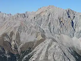 |
Hochwanner | 2,744 | Wetterstein | Hochwanner | 5.5 Zugspitze |
701 Feldernjöchl |
1870 Hermann von Barth |
| 5 | 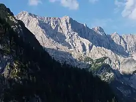 |
Middle Höllentalspitze | 2,743 | Wetterstein | Zugspitze | 1.6 Zugspitze |
116 Jubiläum arête wind-gap to the Zugspitze |
1871 Hermann von Barth |
| 6 | 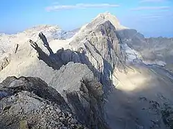 |
Inner Höllentalspitze | 2,741 | Wetterstein | Zugspitze | 0.6 Middle Höllentalspitze |
90 Wind-gap to the Middle Höllentalspitze |
09.09.1871 Hermann von Barth |
| 7 | 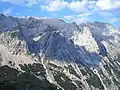 |
Outer Höllentalspitze | 2,720 | Wetterstein | Zugspitze | 0.6 Middle Höllentalspitze |
353 Wind-gap to the Middle Höllentalspitze |
1871 Hermann von Barth |
| 8 | 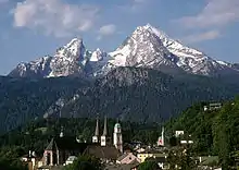 |
Watzmann Middle Peak | 2,713 | Berchtesgaden Alps | Watzmann | 15.9 Hochseiler |
939 Trischübel Pass |
Aug. 1800 Valentin Stanič |
| 9 |  |
Watzmann South Peak | 2,712 | Berchtesgaden Alps | Watzmann | 0.8 Watzmann Middle Peak |
1103 Watzmann arête wind-gap |
1832 Peter Carl Thurwieser |
| 10 | 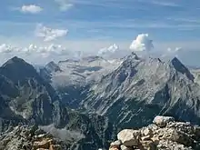 |
Hochblassen | 2,703 | Wetterstein | Zugspitze | 1.1 Outer Höllentalspitze |
143 Falsche Grießkar wind-gap |
25.08.1871 Hermann von Barth, Peter Klaisl |
| 11 | |
Wetterwandeck | 2,698 | Wetterstein | Zugspitze | 0.5 Southern Wetterspitze |
30 Wind-gap to the Eastern Wetterspitze |
|
| 12 | 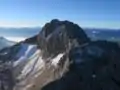 |
Leutascher Dreitorspitze | 2,682 | Wetterstein | Dreitorspitze | 5.2 Hochwanner |
346 Western Wang wind-gap |
07.08.1871 Hermann von Barth |
| 13 | |
Eastern Plattspitze | 2,680 | Wetterstein | Zugspitze | 1.1 Wetterwandeck |
204 Wetter wind-gap |
1871 Hermann von Barth |
| 14 | Hinterreintalschrofen | 2,669 | Wetterstein | Hochwanner | 1.5 Hochwanner |
109 Teufel arête wind-gap to the Hochwanner |
01.09.1871 Hermann von Barth | |
| 15 | 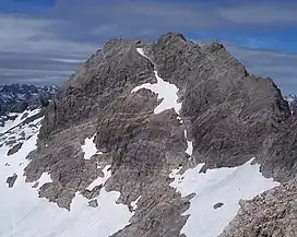 |
Hochfrottspitze | 2,649 | Allgäu Alps | Hohes Licht | 2.2 Hohes Licht |
203 Sock valley wind-gap |
16.06.1869 Hermann von Barth |
| 16 |  |
Mädelegabel | 2,645 | Allgäu Alps | Hohes Licht | 0.4 Hochfrottspitze |
81 Wind-gap to the Hochfrottspitze |
1852 Oskar Sendtner[4]4 |
| 17 | Partenkirchner Dreitorspitze | 2,633 | Wetterstein | Dreitorspitze | 0.5 Leutascher Dreitorspitze |
1003 Wind-gap to the Leutascher Dreitorspitze |
20.07.1854 Jakob Grasegger, Karl Kiendl | |
| 18 | .jpg.webp) |
Alpspitze | 2,628 | Wetterstein | Zugspitze | 0.8 Hochblassen |
165 Grießkar wind-gap |
1825 J. Burger |
| 19 | Vollkarspitze | 2,618 | Wetterstein | Zugspitze | 0.5 Hochblassen |
403 Wind-gap to the Höllentalspitzen |
1897 Ferdinand Henning2 | |
| 20 | Bockkarkopf | 2,609 | Allgäu Alps | Hohes Licht | 0.6 Hochfrottspitze |
106 Bockkar wind-gap |
||
| 21 | 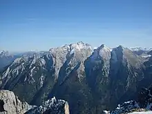 |
Hochkalter | 2,607 | Berchtesgaden Alps | Hochkalter | 4.5 Watzmann |
621 Wimbach wind-gap |
|
| 22 | Northeastern Dreitorspitze | 2,605 | Wetterstein | Dreitorspitze | 0.2 Dreitorspitze |
403 Wind-gap to the Dreitorspitze |
||
| 23 | Biberkopf | 2,599 | Allgäu Alps | Biberkopf | 3.5 Hohes Licht |
337 Große Stein wind-gap |
18535 | |
| 24 | 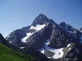 |
Trettachspitze | 2,595 | Allgäu Alps | Hohes Licht | 0.4 Mädelegabel |
1403 Wind-gap to the Mädelegabel |
Aug 1855 Urban, Alois and Mathias Jochum |
| 25 | 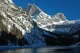 |
Großer Hundstod | 2,593 | Berchtesgaden Alps | Großer Hundstod | 4.5 Watzmann |
474 Dießbach wind-gap |
1825 Karl Thurwieser |
| 26 | 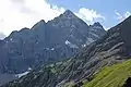 |
Hochvogel | 2,592 | Allgäu Alps | Hochvogel | 5.4 Urbeleskarspitze |
572 Hornbachjoch |
1832 Trobitus |
| 27 |  |
Funtenseetauern | 2,578 | Berchtesgaden Alps | Selbhorn | 4 Selbhorn |
220 Hochbrunnsulzen |
ca. 1865 Johann Grill, Albert Kaindl |
| 28 |  |
Öfnerspitze | 2,576 | Allgäu Alps | Großer Krottenkopf | 0.7 Großer Krottenkopf |
1613 Wind-gap to the Großen Krottenkopf |
18545 |
| 29 |  |
Schüsselkarspitze | 2,551 | Wetterstein | Dreitorspitze | 0.3 Leutascher Dreitorspitze |
603 Wind-gap to the Leutascher Dreitorspitze |
1894 A. Moser, O. Schuster |
| 30 |  |
Krottenspitze | 2,551 | Allgäu Alps | Großer Krottenkopf | 0.3 Öfnerspitze |
78 Wind-gap to the Öfnerspitze |
|
- 1 First recorded climb. Historic maps from the 18th century suggest that the Zugspitze had already been climbed before 1770.[5]
- 2 Year of the first complete crossing of the Jubiläums arête.
- 3 Exact value unknown as no survey has been carried out. Estimate based on contours from a topographical map.
- 4 First recorded climb. It is possible that it had been climbed during survey work in 1818 or work by a border commission in 1835
- 5 As part of a survey
The highest mountains
Table 2 below shows the 21 highest mountains in Germany. A mountain is considered to be the main summit of a massif if its prominence is more than 300 metres.
By clicking the symbols at the head of the table the individual column may be sorted.
| Ranking |
Photograph | Peak | Height (m) |
Mountain range4 | Location | Isolation (km) | Prominence (m) | First climb |
on |
|---|---|---|---|---|---|---|---|---|---|
| 1 | |
Zugspitze | 2,962 | Wetterstein | DE/AT | 24.6 Acherkogel |
1,746 West of the Fernpass |
Josef Naus, Johann Georg Tauschl, Acolyte Maier1 | 27.08.1820 |
| 2 | |
Hochwanner | 2,744 | Wetterstein | DE/AT | 5.5 Zugspitze |
701 Feldernjöchl |
Hermann von Barth | 1870 |
| 3 | |
Watzmann Middle Peak | 2,713 | Berchtesgaden Alps | DE | 15.9 Hochseiler |
939 Trischübel Pass |
Valentin Stanič | Aug 1800 |
| 4 | |
Leutascher Dreitorspitze | 2,682 | Wetterstein | DE/AT | 5.2 Hochwanner |
346 Western Wang wind-gap |
Hermann von Barth | 07.08.1871 |
| 5 | |
Hochkalter | 2,607 | Berchtesgaden Alps | DE | 4.5 Watzmann |
621 Wimbach wind-gap |
||
| 6 | Biberkopf | 2,599 | Allgäu Alps | DE/AT | 3.5 Hohes Licht |
337 Große Stein wind-gap |
18532 | ||
| 7 | |
Großer Hundstod | 2,593 | Berchtesgaden Alps | DE/AT | 4.5 Watzmann |
474 Dießbach wind-gap |
Karl Thurwieser | 1825 |
| 8 | |
Hochvogel | 2,592 | Allgäu Alps | DE/AT | 5.4 Urbeleskarspitze |
572 Hornbachjoch |
Trobitus | 1832 |
| 9 | 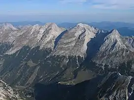 |
Östliche Karwendelspitze | 2,538 | Karwendel | DE/AT | 3.5 Middle Ödkarspitze |
736 Hochalm Saddle |
Hermann von Barth | 04.07.1870 |
| 10 |  |
Hocheisspitze | 2,523 | Berchtesgaden Alps | DE/AT | 3 Hochkalter |
410 Sittersbach wind-gap |
Hermann von Barth | 06.09.1868 |
| 11 | 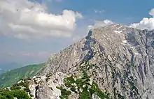 |
Hoher Göll | 2,522 | Berchtesgaden Alps | DE/AT | 11.4 Watzmann |
788 Torrener Joch |
Valentin Stanič | 04.09.1800 |
| 12 | 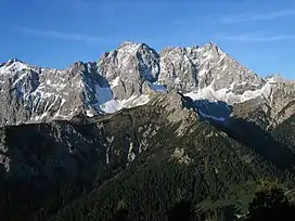 |
Hochkarspitze | 2,482 | Karwendel | DE/AT | 42 Pleisenspitze |
661 Bäralp Saddle |
Hermann von Barth | 1870 |
| 13 | Großes Teufelshorn | 2,361 | Berchtesgaden Alps | DE/AT | 3.8 Reißhorn |
339 Blühnbachtörl |
|||
| 14 | 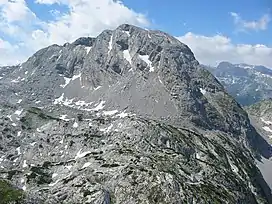 |
Kahlersberg | 2,350 | Berchtesgaden Alps | DE/AT | 4.8 Großes Teufelshorn |
3353 East of the Hintere Bärengrube |
F. v. Schilcher, G. Helblehen | 1854 |
| 15 | 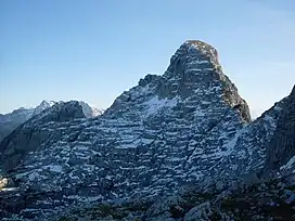 |
Stadelhorn | 2,286 | Berchtesgaden Alps | DE/AT | 5.2 Wasserwandkopf |
1,133 Hirschbichl Pass |
Karl Thurwieser | 1825 |
| 16 |  |
Großer Daumen | 2,280 | Allgäu Alps | DE | 6.4 Kesselspitze |
350 Höfatsblick summit station |
||
| 17 | 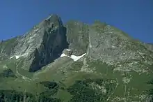 |
Höfats | 2,257 | Allgäu Alps | DE | 2.7 Großer Wilder |
477 Älple Saddle |
Otto Sendtner | 1848 |
| 18 |  |
Soiernspitze | 2,257 | Karwendel | DE | 3.8 Wörner |
833 West of the Vereiner-Alm |
||
| 19 | Hoher Ifen | 2,229 | Allgäu Alps | DE/AT | 7.7 Elferkopf |
476 Gerach Saddle |
|||
| 20 | 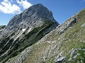 |
Große Arnspitze | 2,196 | Wetterstein | DE/AT | 3.9 Upper Wetterstein peak |
1,003 Northwest of Neuleutasch |
||
| 21 |  |
Kreuzspitze | 2,185 | Ammergau Alps | DE | 10.6 Daniel |
1,182 Upper Schellbach valley |
||
- 1 First recorded climb. Historic maps from the 18th century suggest that the Zugspitze had already been climbed before 1770.[5]
- 2 As part of a survey
- 3 Exact value not known, because it has not been surveyed. Estimate based on contours from a topographical map.
See also
References
- ↑ Or a prominence of 100m according to other authorities.
- ↑ "The Viertausender of the Alpen – Offizielles UIAA-Verzeichnis" (PDF) (in German). UIAA. March 1994. Retrieved 7 May 2009.
- ↑ Bayerische Vermessungsverwaltung. "Bayernviewer". Bayerische Staatsregierung. Archived from the original on 27 March 2009. Retrieved 19 May 2009.
- ↑ "Von Abenteurern and Bergpionieren". allgaeuer-anzeigeblatt.de. 2005. Archived from the original on 18 July 2011. Retrieved 6 May 2009.
- 1 2 Andrea Händel (2006). "Historische Zugspitzkarte". alpenverein.de. Archived from the original on 11 March 2007. Retrieved 6 May 2009.
Literature
- DAV-Karte: 4/3 Wetterstein und Mieminger Kette, eastern sheet (1:25,000). 2005
- DAV-Karte: 5/1 Karwendel, western sheet (1:25,000). 2005
- DAV-Karte: 5/2 Karwendel, middle sheet (1:25,000). 2000
- DAV-Karte: 10/1 Steinernes Meer (1:25,000). 2006
- Kompass Wander-, Bike- and Skitourenkarte: Blatt 3 Allgäu Alps, Kleinwalsertal (1:50.000). Kompass-Karten, Innsbruck 2005, ISBN 978-3-85491-005-3
- Kompass Wander-, Bike and Skitourenkarte: Blatt 03 Oberstdorf, Kleinwalsertal (1:25.000). Kompass-Karten, Innsbruck 2009, ISBN 978-3-85491-231-6
- Kompass Wander-, Bike and Skitourenkarte: Blatt 25 Zugspitze, Mieminger Kette (1:50.000). Kompass-Karten, Innsbruck 2008, ISBN 978-3-85491-026-8
External links
- Bayern-Viewer Archived 27 March 2009 at the Wayback Machine: Online map material for the Federal State of Bavaria
Mountains and hills by state of Germany | ||
|---|---|---|