Kassala State
ولاية كسلا Ash Sharqiyah | |
|---|---|
 | |
 Flag  Seal | |
.svg.png.webp) Location in Sudan. | |
| Coordinates: 15°45′N 35°43′E / 15.750°N 35.717°E | |
| Country | |
| Region | Eastern Sudan States Coordinating Council |
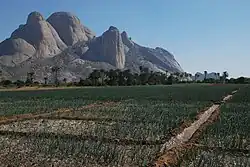
| Capital | Kassala |
| Government | |
| • Governor | vacant |
| Area | |
| • Total | 36,710 km2 (14,170 sq mi) |
| Population (2018) | |
| • Total | 2,519,071[1] |
| Time zone | UTC+2 (CAT) |
| HDI (2017) | 0.453[2] low |
Kassala (Arabic: ولاية كسلا, called Ash Sharqiyah during 1991—1994) is one of the 18 wilayat (states) of Sudan. It has an area of 36,710 km² and an estimated population of approximately 2,519,071 in 2018. Kassala is the capital of the state; other towns in Kassala include Aroma, Hamashkoraib, Halfa el Jadida (New Halfa), Khashm el Girba and Telkuk.[3]
In 2016, Kassala State suffered a severe bread shortage.[4]
Localities
- Kassala (Capital)
- Aroma
- Hamashkoraib
- Halfa el Jadida
- Khashm el Girba
- Telkuk
- Wad al Hulaywah
References
- ↑ "Archived copy" (PDF). Archived from the original (PDF) on 2017-03-12. Retrieved 2023-06-09.
{{cite web}}: CS1 maint: archived copy as title (link) - ↑ "Sub-national HDI - Area Database - Global Data Lab". hdi.globaldatalab.org. Retrieved 2018-09-13.
- ↑ "Sudan Tribune: Plural news and views on Sudan". sudantribune.com. Retrieved 2018-02-09.
- ↑ "Eastern Sudan: No water in Aroma, no bread in Kassala". Radio Dabanga. 2016-03-17. Retrieved 2018-02-09.
This article is issued from Wikipedia. The text is licensed under Creative Commons - Attribution - Sharealike. Additional terms may apply for the media files.