| Mendawai River Soengai Katingin, Soengai Mendawei, Soengai Ketingan, Mendawi, Soengai Katingan | |
|---|---|
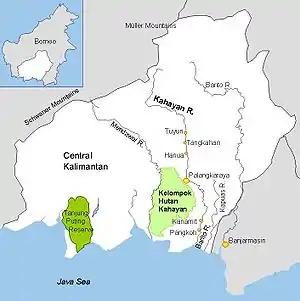 Mendawai and other rivers in Central Kalimantan | |
 | |
| Native name | Sungai Mendawai (Indonesian) |
| Location | |
| Country | Indonesia |
| Province | Central Kalimantan |
| Physical characteristics | |
| Source | Schwaner Mountains |
| Mouth | Java Sea |
• location | Pagatan |
• coordinates | 3°5.1242′S 113°18.6542′E / 3.0854033°S 113.3109033°E |
| Length | 616 km (383 mi) |
| Basin size | 19,500 km2 (7,500 sq mi)[1] |
| Discharge | |
| • location | Katingan Kuala (Katingan Regency), Java Sea (near mouth) |
| • average | 1,414 m3/s (49,900 cu ft/s)[2] |
| Discharge | |
| • location | Kasongan |
| • average | 1,279 m3/s (45,200 cu ft/s)[3] |
| Basin features | |
| River system | Katingan basin (DAS320369)[1] |
Mendawai River or Katingan River is a river of Borneo, it is located in Central Kalimantan, Indonesia. With a total length of 616 km (383 mi).[4][5] The longhouses of the Pendahara are located along the river in its upper course. The river has its source in the Schwaner Mountain Range.[6]
Geography
The river flows in the southeast area of Borneo with predominantly tropical rainforest climate (designated as Af in the Köppen-Geiger climate classification).[7] The annual average temperature in the area is 22 °C. The warmest month is September, when the average temperature is around 24 °C, and the coldest is December, at 20 °C.[8] The average annual rainfall is 2991 mm. The wettest month is December, with an average of 476 mm rainfall, and the driest is September, with 75 mm rainfall.[9]
See also
References
- 1 2 Hukum Online. "Keputusan Menteri Kehutanan No. SK.511/MENHUT-V/2011" (in Indonesian).
- ↑ Kevin, Telmer; Daniel, Stapper (Nov 2007). "Evaluating and Monitoring Small Scale Gold Mining and Mercury Use: Building a Knowledge-base with Satellite Imagery and Field Work".
- ↑ Daniel, Stapper (2011). "Artisanal Gold Mining, Mercury and Sediment in Central Kalimantan, Indonesia" (PDF).
- ↑ Rand McNally, The New International Atlas, 1993.
- ↑ Sungai Mendawai - Geonames.org.
- ↑ "Central Kalimantan". Goarchi. Retrieved October 30, 2010.
- ↑ Peel, M C; Finlayson, B L; McMahon, T A (2007). "Updated world map of the Köppen-Geiger climate classification". Hydrology and Earth System Sciences. 11 (5): 1633–1644. doi:10.5194/hess-11-1633-2007.
- ↑ "NASA Earth Observations Data Set Index". NASA. 30 January 2016.
- ↑ "NASA Earth Observations: Rainfall (1 month - TRMM)". NASA/Tropical Rainfall Monitoring Mission. 30 January 2016.