Native name: Κολοκύθα | |
|---|---|
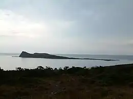 The islet of Kolokytha. | |
 Kolokytha | |
| Geography | |
| Coordinates | 35°15′50″N 25°45′36″E / 35.264°N 25.760°E |
| Archipelago | Cretan Islands |
| Area | 0.144 km2 (0.056 sq mi) |
| Administration | |
Greece | |
| Region | Crete |
| Regional unit | Lasithi |
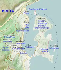
Map of Elounda, Spinalonga and surrounding areas.
Kolokytha (Greek: Κολοκύθα "pumpkin", also known as Κολοκυθιά, Kolokythia) is a Greek islet. It is part of municipality Agios Nikolaos of the regional unit Lasithi, eastern Crete. It is located approximately 850 meters east of the Spinalonga peninsula and forms a bay with it.
See also
References
This article is issued from Wikipedia. The text is licensed under Creative Commons - Attribution - Sharealike. Additional terms may apply for the media files.