| Léez | |
|---|---|
%252C_le_L%C3%A9es_ou_L%C3%A9ez.JPG.webp) | |
  | |
| Location | |
| Country | France |
| Physical characteristics | |
| Source | |
| • location | near Gardères |
| Mouth | |
• location | Adour |
• coordinates | 43°41′12″N 0°14′39″W / 43.68667°N 0.24417°W |
| Length | 56 km (35 mi) |
| Basin features | |
| Progression | Adour→ Atlantic Ocean |
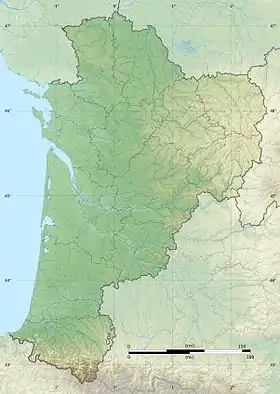
The Léez (Leez, Lées, Léès, Lees) is a left tributary of the Adour, in the Southwest of France. It is 56.2 km (34.9 mi) long.[1]
Name
This name proceeds from an Aquitanian hydronym Lez / Liz.
Geography
The Léez rises near Gardères in the north of the plateau of Ger. It flows north through the Vic-Bilh area in the east of the Pyrénées-Atlantiques and joins the Adour in the French département of the Gers, upstream from Aire-sur-l'Adour.
Main tributaries
- (L) the Petit-Léez,
- (L) the Gabassot,
- (R) the Larcis,
- (R) the canal of Bernède, long of 2 km, fed by the Adour.
References
This article is issued from Wikipedia. The text is licensed under Creative Commons - Attribution - Sharealike. Additional terms may apply for the media files.