| Lăpuș | |
|---|---|
.JPG.webp) The Lăpuș at Preluca Nouă | |
 | |
| Location | |
| Country | Romania |
| Counties | Maramureș County |
| Towns | Târgu Lăpuș, Șomcuta Mare |
| Physical characteristics | |
| Source | Lăpuș Mountains |
| Mouth | Someș |
• coordinates | 47°39′22″N 23°24′05″E / 47.65611°N 23.40139°E |
• elevation | 143 m (469 ft) |
| Length | 119 km (74 mi) |
| Basin size | 1,875 km2 (724 sq mi) |
| Basin features | |
| Progression | Someș→ Tisza→ Danube→ Black Sea |
| Tributaries | |
| • left | Suciu |
| • right | Cavnic, Săsar |
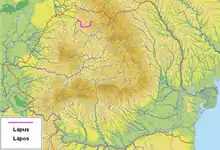
The Lăpuș (Hungarian: Lápos) is a right tributary of the river Someș in Romania.[1][2] It originates in the Lăpuș Mountains, Maramureș County. It discharges into the Someș in Bușag, west of Baia Mare.[3] It flows through the communes Băiuț, Lăpuș, Târgu Lăpuș, Vima Mică, Șomcuta Mare, Remetea Chioarului, Coaș, Săcălășeni, Groși, Coltău, Recea and Tăuții-Măgherăuș. Its length is 119 km (74 mi) and its basin size is 1,875 km2 (724 sq mi).[2]
Tributaries
The following rivers are tributaries to the river Lăpuș (from source to mouth):[2]
References
- ↑ "Planul național de management. Sinteza planurilor de management la nivel de bazine/spații hidrografice, anexa 7.1" (PDF, 5.1 MB). Administrația Națională Apele Române. 2010. pp. 109–110.
- 1 2 3 Atlasul cadastrului apelor din România. Partea 1 (in Romanian). Bucharest: Ministerul Mediului. 1992. pp. 83–86. OCLC 895459847. River code: II.1.66
- ↑ Lapus (jud. Maramures), e-calauza.ro
This article is issued from Wikipedia. The text is licensed under Creative Commons - Attribution - Sharealike. Additional terms may apply for the media files.