| Erie Hill | |
|---|---|
 | |
| Highest point | |
| Elevation | 690 m (2,260 ft)[1] |
| Prominence | 92 m (302 ft)[1] |
| Listing | Tu,Sim, D,sHu,GT,DN[1] |
| Geography | |
| Location | Scottish Borders, Scotland |
| Parent range | Moffat Hills, Southern Uplands |
| OS grid | NT 12411 18736 |
| Topo map | OS Landranger 78 |
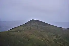
Erie Hill is a hill in the Moffat Hills range, part of the Southern Uplands of Scotland. A relatively compact summit in comparison to the other hills in the range, it is commonly climbed as part of a round starting from Talla Linnfoots to the north.[1]
Subsidiary SMC Summits
| Summit | Height (m) | Listing[2] |
|---|---|---|
| Laird's Cleuch Rig | 684 | Tu,Sim,DT,GT,DN[3] |
| Garelet Hill | 681 | DT,sSim[4] |
References
- 1 2 3 4 "Erie Hill". Hill-bagging.co.uk. Retrieved 23 April 2020.
- ↑ Chris Crocker. "Database of British and Irish Hills: user guide". Hills-database.co.uk. Retrieved 23 April 2020.
- ↑ "Laird's Cleuch Rig [Lairds Cleuch Rig]". Hill-bagging.co.uk. Retrieved 23 April 2020.
- ↑ "Garelet Hill". Hill-bagging.co.uk. Retrieved 23 April 2020.
This article is issued from Wikipedia. The text is licensed under Creative Commons - Attribution - Sharealike. Additional terms may apply for the media files.