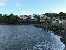
Le Marigot | |
|---|---|
 | |
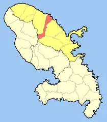 Location of the commune (in red) within Martinique | |
Location of Le Marigot | |
| Coordinates: 14°49′N 61°02′W / 14.82°N 61.03°W | |
| Country | France |
| Overseas region and department | Martinique |
| Arrondissement | La Trinité |
| Intercommunality | CAP Nord Martinique |
| Government | |
| • Mayor (2020–2026) | Joseph Péraste[1] |
| Area 1 | 21.63 km2 (8.35 sq mi) |
| Population | 3,034 |
| • Density | 140/km2 (360/sq mi) |
| Demonym(s) | Marigotin, Marigotine (French) |
| Time zone | UTC−04:00 (AST) |
| INSEE/Postal code | 97216 /97225 |
| Elevation | 0–694 m (0–2,277 ft) |
| 1 French Land Register data, which excludes lakes, ponds, glaciers > 1 km2 (0.386 sq mi or 247 acres) and river estuaries. | |
Le Marigot (French pronunciation: [lə maʁiɡo]; Martinican Creole: Mawigo) is a village and commune in the French overseas department of Martinique.
Population
| Year | Pop. | ±% p.a. |
|---|---|---|
| 1967 | 3,715 | — |
| 1974 | 3,842 | +0.48% |
| 1982 | 3,498 | −1.17% |
| 1990 | 3,587 | +0.31% |
| 1999 | 3,663 | +0.23% |
| 2007 | 3,700 | +0.13% |
| 2012 | 3,568 | −0.72% |
| 2017 | 3,196 | −2.18% |
| Source: INSEE[3] | ||
See also
References
- ↑ "Répertoire national des élus: les maires" (in French). data.gouv.fr, Plateforme ouverte des données publiques françaises. 13 September 2022.
- ↑ "Populations légales 2021". The National Institute of Statistics and Economic Studies. 28 December 2023.
- ↑ Population en historique depuis 1968, INSEE
External links
Wikimedia Commons has media related to Le Marigot.
- Base Mérimée: Search for heritage in the commune, Ministère français de la Culture. (in French)
This article is issued from Wikipedia. The text is licensed under Creative Commons - Attribution - Sharealike. Additional terms may apply for the media files.