Môle-Saint-Nicolas Arrondissement
Mòl Sen Nikola Awondisman | |
|---|---|
 | |
| Coordinates: 19°48′00″N 73°23′00″W / 19.8°N 73.3833°W | |
| Country | |
| Department | Nord-Ouest |
| Area | |
| • Arrondissement | 1,115.43 km2 (430.67 sq mi) |
| • Urban | 3.4 km2 (1.3 sq mi) |
| • Rural | 1,112.03 km2 (429.36 sq mi) |
| Population (2015)[1] | |
| • Arrondissement | 245,590 |
| • Density | 220/km2 (570/sq mi) |
| • Urban | 23,539 |
| • Rural | 222,051 |
| Time zone | UTC-5 (Eastern) |
| Postal code | HT33— |
| Communes | 4 |
| Communal Sections | 17 |
| IHSI Code | 093 |
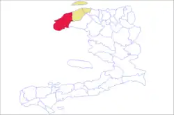
Môle-Saint-Nicolas (Haitian Creole: Mòl Sen Nikola) is an arrondissement in the Nord-Ouest Department of Haiti. As of 2015, the population was 245,590 inhabitants.[1] Postal codes in the Môle-Saint-Nicolas Arrondissement start with the number 33.
The arrondissement consists of the following communes:
References
- 1 2 3 "Population totale, population de 18 ans et plus ménages et densités estimés en 2015" [Total Population, Population of 18 and over, Households and Densities Estimated in 2015] (PDF). IHSI (in French). March 2015. Retrieved 8 May 2017.
This article is issued from Wikipedia. The text is licensed under Creative Commons - Attribution - Sharealike. Additional terms may apply for the media files.