Township of Marrs Hill | |
|---|---|
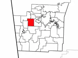 Location of Marrs Hill Township in Washington County | |
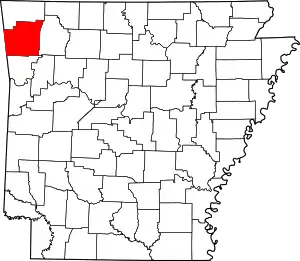 Location of Washington County in Arkansas | |
| Coordinates: 36°2′15″N 94°20′21″W / 36.03750°N 94.33917°W | |
| Country | |
| State | |
| County | Washington |
| Established | before 1850 |
| Area | |
| • Total | 20.6 sq mi (53 km2) |
| • Land | 20.6 sq mi (53 km2) |
| • Water | 0.0 sq mi (0 km2) 0% |
| Elevation | 1,106 ft (337 m) |
| Population (2000) | |
| • Total | 898 |
| • Density | 44/sq mi (17/km2) |
| Time zone | UTC-6 (CST) |
| • Summer (DST) | UTC-5 (CDT) |
| Area code | 479 |
| GNIS feature ID | 69795[1] |
Marrs Hill Township (formerly Mars Hill, Mar Hill, and Marr's Hill) is one of thirty-seven townships in Washington County, Arkansas, USA.[2] As of the 2000 census, its total population was 898.
Geography
According to the United States Census Bureau, Marrs Hill Township covers an area of 20.6 square miles (53 km2); all land.[2]
Cities, towns, villages
- Jabur (historical)
- Rickert (historical)
- Viney Grove
Cemeteries
The township contains Bell Cemetery and Rose Cemetery.
Major routes
The township contains no state highways.
References
- 1 2 U.S. Geological Survey Geographic Names Information System: Marrs Hill Township, Washington County, Arkansas
- 1 2 "Township of Marr's Hill, Washington County, Arkansas". U.S. Census Bureau. Retrieved September 15, 2011.
External links
Places adjacent to Marrs Hill Township, Washington County, Arkansas | ||||||||||||||||
|---|---|---|---|---|---|---|---|---|---|---|---|---|---|---|---|---|
| ||||||||||||||||
This article is issued from Wikipedia. The text is licensed under Creative Commons - Attribution - Sharealike. Additional terms may apply for the media files.