Merrill Township, North Dakota | |
|---|---|
 Merrill Township, North Dakota Location within the state of North Dakota | |
| Coordinates: 46°14′57″N 102°12′35″W / 46.24917°N 102.20972°W | |
| Country | United States |
| State | North Dakota |
| County | Hettinger |
| Area | |
| • Total | 32.3 sq mi (83.8 km2) |
| • Land | 32.1 sq mi (83.1 km2) |
| • Water | 0.3 sq mi (0.7 km2) |
| Elevation | 2,448 ft (746 m) |
| Population (2000) | |
| • Total | 13 |
| • Density | 0.4/sq mi (0.2/km2) |
| Time zone | UTC-7 (Mountain (MST)) |
| • Summer (DST) | UTC-6 (MDT) |
| Area code | 701 |
| FIPS code | 38-52540[1] |
| GNIS feature ID | 1037210[2] |
Merrill is a township in Hettinger County, North Dakota, United States. The population was 13 at the 2000 census.[3]
References
- ↑ "U.S. Census website". United States Census Bureau. Retrieved January 31, 2008.
- ↑ "US Board on Geographic Names". United States Geological Survey. October 25, 2007. Retrieved January 31, 2008.
- ↑
U.S. Census Bureau. Census 2000. "Census Demographic Profiles, Merrill Township, Hettinger County, North Dakota" (PDF). CenStats Databases. Retrieved January 31, 2009.
{{cite web}}: CS1 maint: numeric names: authors list (link)
Municipalities and communities of Hettinger County, North Dakota, United States | ||
|---|---|---|
| Cities | 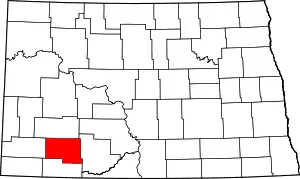 Map of North Dakota highlighting Hettinger County | |
| Townships | ||
| Unorganized territory |
| |
| Unincorporated communities | ||
This article is issued from Wikipedia. The text is licensed under Creative Commons - Attribution - Sharealike. Additional terms may apply for the media files.