Poço Redondo | |
|---|---|
Municipality | |
| The Municipality of Poço Redondo | |
 Flag  Seal | |
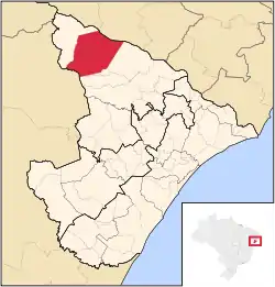 Location of Poço Redondo in the State of Sergipe | |
| Coordinates: 09°48′21″S 37°41′06″W / 9.80583°S 37.68500°W | |
| Country | |
| Region | Northeast |
| State | |
| Founded | 1953 |
| Government | |
| • Mayor | Frei Enoque Salvador de Melo (PSB) |
| Area | |
| • Total | 1,212.461 km2 (468.134 sq mi) |
| Elevation | 188 m (617 ft) |
| Population (2020 [1]) | |
| • Total | 35,122 |
| • Density | 29/km2 (75/sq mi) |
| Time zone | UTC−3 (BRT) |
| HDI (2000) | 0.536 – medium[2] |
| Climate | BSh |
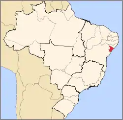
Poço Redondo is a municipality located in the Brazilian state of Sergipe. Its population is 35,122 (2020) and its area is 1,212 km²,[3] which makes it the largest municipality in that state.
References
- ↑ "IBGE 2020". Retrieved 26 January 2021.
- ↑ Archived 2009-10-03 at the Wayback Machine - UNDP
- ↑ IBGE -
Capital: Aracaju | |||||||||||||||
| Agreste Sergipano |
|  | |||||||||||||
| Leste Sergipano |
| ||||||||||||||
| Sertao Sergipano |
| ||||||||||||||
This article is issued from Wikipedia. The text is licensed under Creative Commons - Attribution - Sharealike. Additional terms may apply for the media files.