| Q'ara Wayuna | |
|---|---|
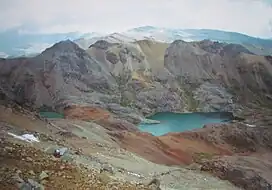 The western extensions of the Chunta mountain range as seen from Sukullu (looking to the south). Q'ara Wayuna lies in the background | |
| Highest point | |
| Elevation | 4,800 m (15,700 ft)[1] |
| Coordinates | 13°01′47″S 75°22′30″W / 13.02972°S 75.37500°W |
| Geography | |
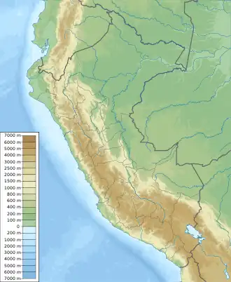 Q'ara Wayuna Peru | |
| Location | Peru, Huancavelica Region |
| Parent range | Andes, Chunta |
Q'ara Wayuna (Quechua q'ara bare, naked, wayuna basket,[2] "bare basket", Hispanicized spelling Jarahuayuna) is a mountain in the Chunta mountain range in the Andes of Peru, about 4,800 m (15,700 ft) high. It is located in the Huancavelica Region, Castrovirreyna Province, on the border of the districts of Aurahuá and Castrovirreyna. It lies southwest of Sukullu and a lake named Antaqucha ("copper lake", Hispanicized Antacocha).[1]
References
- 1 2 escale.minedu.gob.pe - UGEL map of the Castrovirreyna Province (Huancavelica Region)
- ↑ "Diccionario: Quechua - Español - Quechua, Simi Taqe: Qheswa - Español - Qheswa" (PDF). Diccionario Quechua - Español - Quechua. Gobierno Regional del Cusco, Perú: Academía Mayor de la Lengua Quechua. 2005. , see: waracha
This article is issued from Wikipedia. The text is licensed under Creative Commons - Attribution - Sharealike. Additional terms may apply for the media files.