Route 153 | ||||
|---|---|---|---|---|
 | ||||
| Route information | ||||
| Maintained by Transports Québec | ||||
| Length | 94.6 km[1] (58.8 mi) | |||
| Major junctions | ||||
| South end | ||||
| North end | ||||
| Location | ||||
| Country | Canada | |||
| Province | Quebec | |||
| Highway system | ||||
| ||||

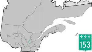
Route 153 is a two-lane north–south highway in Quebec, Canada, which starts in Yamachiche at the junction of Autoroute 40 and ends in Lac-aux-Sables at the junction of Route 363.
Municipalities along Route 153
Major intersections
| RCM or ET | Municipality | Km | Junction | Notes |
|---|---|---|---|---|
Southern terminus of Route 153 | ||||
| Maskinongé | Yamachiche | 0.0 0.4 |
40 WEST: to Louiseville 40 EAST: to Pointe-du-Lac (Trois-Rivières) | |
| 2.4 | 138 WEST: to Louiseville 138 EAST: to Pointe-du-Lac (Trois-Rivières) | |||
| 5.7 | Route de Saint-Sévère | NORTH: to Saint-Sévère | ||
| Saint-Barnabé | 18.5 | Chemin de la Grande-Rivière | EAST: to Saint-Étienne-des-Grès | |
| 19.5 | 351 NORTH: to Charette | |||
| Saint-Boniface | 28.7 | 350 WEST: to Charette | ||
| 37.1 | 55 SOUTH/155 SOUTH: to Saint-Étienne-des-Grès | |||
| 37.6 | 55 NORTH/155 NORTH: to Shawinigan | |||
| Shawinigan | Shawinigan | 41.9 | 157 SOUTH: to Shawinigan-Sud (Shawinigan) | |
| 43.0 | 351 SOUTH: to Saint-Gérard-des-Laurentides (Shawinigan) | |||
| 55.5 | 359 SOUTH: to Lac-a-la-Tortue (Shawinigan) | |||
| 57.8 | 90e Avenue | WEST: to | ||
| Mékinac | Saint-Tite | 70.1 70.9 |
159 NORTH: to Saint-Roch-de-Mékinac 159 SOUTH: to Saint-Séverin | |
| Sainte-Thècle | 82.3 | 352 WEST: to Saint-Adelphe | ||
| Lac-aux-Sables | 94.6 | 363 SOUTH: to Notre-Dame-de-Montauban | ||
Northern terminus of Route 153 | ||||
See also
References
- ↑ Ministère des transports, "Distances routières", page 71, Les Publications du Québec, 2005
External links
- Provincial Route Map (Courtesy of the Quebec Ministry of Transportation) (in French)
- Route 153 on Google Maps
This article is issued from Wikipedia. The text is licensed under Creative Commons - Attribution - Sharealike. Additional terms may apply for the media files.