Saint-Paul-d'Abbotsford | |
|---|---|
 | |
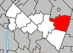 Location within Rouville RCM | |
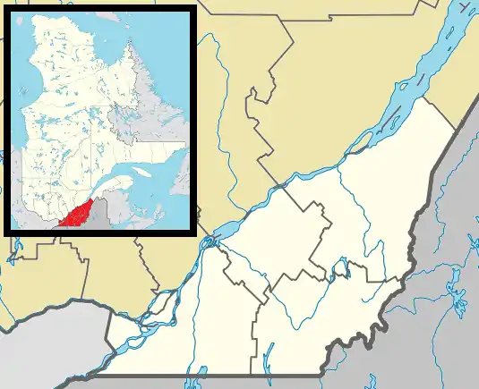 Saint-Paul-d'Abbotsford Location in southern Quebec | |
| Coordinates: 45°26′N 72°53′W / 45.433°N 72.883°W[1] | |
| Country | Canada |
| Province | Quebec |
| Region | Montérégie |
| RCM | Rouville |
| Constituted | July 1, 1855 |
| Government | |
| • Mayor | Robert Vynke (2017) |
| • Federal riding | Shefford |
| • Prov. riding | Iberville |
| Area | |
| • Total | 80.20 km2 (30.97 sq mi) |
| • Land | 79.45 km2 (30.68 sq mi) |
| Population (2011)[4] | |
| • Total | 2,870 |
| • Density | 36.1/km2 (93/sq mi) |
| • Pop 2006-2011 | |
| • Dwellings | 1,164 |
| Time zone | UTC−05:00 (EST) |
| • Summer (DST) | UTC−04:00 (EDT) |
| Postal code(s) | |
| Area code(s) | 450 and 579 |
| Highways | |
| Website | www.saint pauldabbotsford.qc.ca |
Saint-Paul-d'Abbotsford is a municipality in the Canadian province of Quebec, located within the Rouville Regional County Municipality in the province's Montérégie region. The population as of the 2011 Canadian Census was 2,870.
Demographics
PopulationPopulation trend:[5]
|
LanguageMother tongue language (2006)[6]
|
See also
References
- ↑ "Banque de noms de lieux du Québec: Reference number 402426". toponymie.gouv.qc.ca (in French). Commission de toponymie du Québec.
- 1 2 Ministère des Affaires municipales, des Régions et de l'Occupation du territoire: Saint-Paul-d'Abbotsford
- ↑ Parliament of Canada Federal Riding History: SHEFFORD (Quebec)
- 1 2 2011 Statistics Canada Census Profile: Saint-Paul-d'Abbotsford, Quebec
- ↑ Statistics Canada: 1996, 2001, 2006, 2011 census
- ↑ 2006 Statistics Canada Community Profile: Saint-Paul-d'Abbotsford, Quebec
Wikimedia Commons has media related to Saint-Paul-d'Abbotsford.
Adjacent Municipal Subdivisions | ||||||||||||||||
|---|---|---|---|---|---|---|---|---|---|---|---|---|---|---|---|---|
| ||||||||||||||||
| Cities | |
|---|---|
| Municipalities | |
| |
This article is issued from Wikipedia. The text is licensed under Creative Commons - Attribution - Sharealike. Additional terms may apply for the media files.