Springwater Colony, Montana | |
|---|---|
 Springwater Colony  Springwater Colony | |
| Coordinates: 46°27′28″N 109°45′16″W / 46.45778°N 109.75444°W | |
| Country | United States |
| State | Montana |
| County | Wheatland |
| Area | |
| • Total | 0.23 sq mi (0.61 km2) |
| • Land | 0.23 sq mi (0.61 km2) |
| • Water | 0.00 sq mi (0.00 km2) |
| Elevation | 4,432 ft (1,351 m) |
| Population (2020) | |
| • Total | 119 |
| • Density | 508.55/sq mi (196.06/km2) |
| Time zone | UTC-7 (Mountain (MST)) |
| • Summer (DST) | UTC-6 (MDT) |
| ZIP Code | 59036 (Harlowton) |
| Area code | 406 |
| FIPS code | 30-70434 |
| GNIS feature ID | 2804319[2] |
Springwater Colony is a Hutterite community[3] and census-designated place (CDP) in Wheatland County, Montana, United States. It is in the east-central part of the county, 4 miles (6 km) northeast of Harlowton, the county seat.
The community was first listed as a CDP prior to the 2020 census.[2]
Demographics
| Census | Pop. | Note | %± |
|---|---|---|---|
| 2020 | 119 | — | |
| U.S. Decennial Census[4] | |||
Education
It is zoned to Harlowton Public Schools.[5]
References
- ↑ "ArcGIS REST Services Directory". United States Census Bureau. Retrieved September 5, 2022.
- 1 2 "Springwater Colony Census Designated Place". Geographic Names Information System. United States Geological Survey, United States Department of the Interior.
- ↑ Morton, Claudette, ed. (2010). Essential Understandings of Montana Hutterites: A Resource for Educators and Students (PDF). Montana Office of Public Instruction. p. 2. Retrieved June 16, 2021.
- ↑ "Census of Population and Housing". Census.gov. Retrieved June 4, 2016.
- ↑ "2020 CENSUS - SCHOOL DISTRICT REFERENCE MAP: Wheatland County, MT" (PDF). U.S. Census Bureau. Retrieved October 7, 2022.
Municipalities and communities of Wheatland County, Montana, United States | ||
|---|---|---|
| Cities | 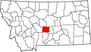 Wheatland County map | |
| CDPs | ||
This article is issued from Wikipedia. The text is licensed under Creative Commons - Attribution - Sharealike. Additional terms may apply for the media files.