| Statistical regions of North Macedonia | |
|---|---|
 | |
| Category | Unitary state |
| Location | North Macedonia |
| Number | 8 statistical regions |
| Populations | 138,722 (Vardar) – 607,007 (Skopje) |
| Government | |
| Subdivisions | |
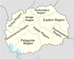
North Macedonia is divided into eight statistical regions.[1]
Regions
| Region | Area (km2) |
Macedonian name | Population (2021 census) | Largest city |
|---|---|---|---|---|
| Eastern | 3,537 | Источен регион | 150,234 | Štip |
| Northeastern | 2,310 | Североисточен регион | 152,982 | Kumanovo |
| Pelagonia | 4,717 | Пелагониски регион | 210,431 | Bitola |
| Polog | 2,416 | Полошки регион | 251,552 | Tetovo |
| Skopje | 1,812 | Скопски регион | 607,007 | Skopje |
| Southeastern | 2,739 | Југоисточен регион | 148,387 | Strumica |
| Southwestern | 3,340 | Југозападен регион | 177,398 | Ohrid |
| Vardar | 4,042 | Вардарски регион | 138,722 | Veles |
See also
Wikimedia Commons has media related to Statistical regions of North Macedonia.
References
- ↑ "General and Regional Statistics". State Statistical Office of the Republic of North Macedonia. Retrieved 31 August 2010.
North Macedonia articles | ||||||||||||
|---|---|---|---|---|---|---|---|---|---|---|---|---|
| History |
|  | ||||||||||
| Geography | ||||||||||||
| Politics | ||||||||||||
| Economy | ||||||||||||
| Society |
| |||||||||||
This article is issued from Wikipedia. The text is licensed under Creative Commons - Attribution - Sharealike. Additional terms may apply for the media files.