al-Zabadani District
منطقة الزبداني | |
|---|---|
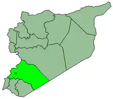
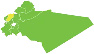 Map of al-Zabadani District within Rif Dimashq Governorate | |
| Coordinates (al-Zabadani): 33°43′N 36°05′E / 33.72°N 36.08°E | |
| Country | |
| Governorate | Rif Dimashq |
| Seat | al-Zabadani |
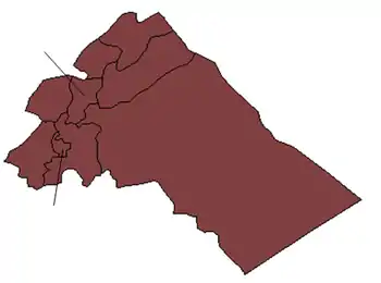
| Subdistricts | 3 nawāḥī |
| Area | |
| • Total | 393.42 km2 (151.90 sq mi) |
| Population (2004)[1] | |
| • Total | 63,780 |
| • Density | 160/km2 (420/sq mi) |
| Geocode | SY0307 |
al-Zabadani District (Arabic: منطقة الزبداني, romanized: manṭiqat al-Zabadani) is a district of the Rif Dimashq Governorate in southern Syria. Administrative centre is the city of al-Zabadani. At the 2004 census, the district had a population of 63,780.[1]
Until February 2009, the sub-districts of Ayn al-Fijah and al-Dimas were part of Al-Zabadani District before being incorporated to form the newly established Qudsaya District.[2]
The town-resort of Bloudan in the al-Zabadani district is a favourite tourist destination for locals and foreigners.
Sub-districts
The district of al-Zabadani is divided into three sub-districts or nawāḥī (population as of 2004[1]):
| Code | Name | Area | Population |
|---|---|---|---|
| SY030700 | al-Zabadani Subdistrict | 178.67 km² | 40,613 |
| SY030701 | Madaya Subdistrict | 93.37 km² | 13,692 |
| SY030702 | Serghaya Subdistrict | 121.37 km² | 9,475 |
Settlements
According to the Central Bureau of Statistics (CBS), the following villages, towns and cities make up the district of al-Zabadani:[1]
| English Name | Arabic Name | Population | Subdistrict |
|---|---|---|---|
| al-Zabadani | الزبداني | 26,285 | al-Zabadani |
| Madaya | مضايا | 9,371 | Madaya |
| Serghaya | سرغايا | 7,501 | Serghaya |
| al-Rawdah (al-Batrounah) | (الروضة (البطرونة | 4,536 | al-Zabadani |
| Souq Wadi Barada | سوق وادي بردى | 3,678 | al-Zabadani |
| Bloudan | بلودان | 3,101 | al-Zabadani |
| Hurayra | هريرة | 2,455 | Madaya |
| Ain Hawr | عين حور | 1,974 | Serghaya |
| Baqin | بقين | 1,866 | Madaya |
| Kafr al-Awamid | كفر العواميد | 1,588 | al-Zabadani |
| Barheliya | برهليا | 821 | al-Zabadani |
| Hosh Bajed | حوش بجد | 604 | al-Zabadani |
References
- 1 2 3 4 "General Census of Population and Housing 2004" (PDF) (in Arabic). Syrian Central Bureau of Statistics. Archived from the original (PDF) on 8 December 2015. Retrieved 15 October 2015.
Also available in English: "2004 Census Data". UN OCHA. Retrieved 15 October 2015. - ↑ New presidential decree to form Qudsaya district
|   | ||||||||||||||||||
|
| |||||||||||||||||||
| |||||||||||||||||||
| |||||||||||||||||||
| |||||||||||||||||||
| |||||||||||||||||||
| |||||||||||||||||||
| |||||||||||||||||||
| |||||||||||||||||||