Épineu-le-Chevreuil | |
|---|---|
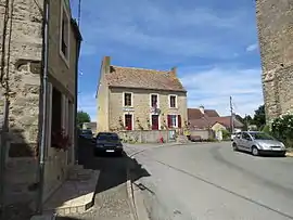 The town hall of Épineu-le-Chevreuil | |
.svg.png.webp) Coat of arms | |
Location of Épineu-le-Chevreuil | |
 Épineu-le-Chevreuil 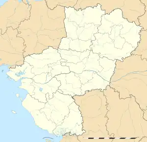 Épineu-le-Chevreuil | |
| Coordinates: 48°02′19″N 0°06′51″W / 48.0386°N 0.1142°W | |
| Country | France |
| Region | Pays de la Loire |
| Department | Sarthe |
| Arrondissement | La Flèche |
| Canton | Loué |
| Intercommunality | Loué - Brûlon - Noyen |
| Government | |
| • Mayor (2020–2026) | Sébastien Huet[1] |
| Area 1 | 14.70 km2 (5.68 sq mi) |
| Population | 295 |
| • Density | 20/km2 (52/sq mi) |
| Demonym(s) | Spinéen, Spinéenne |
| Time zone | UTC+01:00 (CET) |
| • Summer (DST) | UTC+02:00 (CEST) |
| INSEE/Postal code | 72126 /72540 |
| Elevation | 72–161 m (236–528 ft) |
| 1 French Land Register data, which excludes lakes, ponds, glaciers > 1 km2 (0.386 sq mi or 247 acres) and river estuaries. | |
Épineu-le-Chevreuil (French pronunciation: [epinø lə ʃəvʁœj]) is a commune in the Sarthe department in the Pays de la Loire region in north-western France.
Geography
The river Vègre flows southwestward through the eastern part of the commune, then forms part of its southern border.
See also
References
- ↑ "Répertoire national des élus: les maires". data.gouv.fr, Plateforme ouverte des données publiques françaises (in French). 2 December 2020.
- ↑ "Populations légales 2021". The National Institute of Statistics and Economic Studies. 28 December 2023.
Wikimedia Commons has media related to Épineu-le-Chevreuil.
This article is issued from Wikipedia. The text is licensed under Creative Commons - Attribution - Sharealike. Additional terms may apply for the media files.