| Abbas Combe | |
|---|---|
 | |
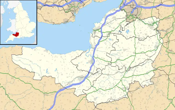 Abbas Combe Location within Somerset | |
| OS grid reference | ST7022 |
| Civil parish | |
| Unitary authority | |
| Ceremonial county | |
| Region | |
| Country | England |
| Sovereign state | United Kingdom |
| Post town | Templecombe |
| Postcode district | BA8 |
| Dialling code | 01963 |
| Police | Avon and Somerset |
| Fire | Devon and Somerset |
| Ambulance | South Western |
| UK Parliament | |
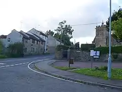
Abbas Combe is a village in the civil parish of Abbas and Templecombe, in the county of Somerset, England. It is situated on the A357 road beside Templecombe, seven miles south west of Gillingham.[1][2] As of 2002 the parish of Abbas and Templecombe had a population of 1,510.[3] The modern area now known as Abbas Combe is now considered more of a part of Templecombe. The border is fuzzy however it's mostly the areas of Templecombe located north of the Railway Station.[2] Abbas Combe consists of a few buildings and structures such as a church, a resovoir, farm, War Memorial, and many other buildings. Other than those Abbas Combe is entirely residential.[1][2]
Abbas Combe isn't served directly by any public transport routes but is right by Templecombe railway station.[4]
Abbas Combe is recorded in the Domesday Book of 1086-7 as Cumbe, when it was held by the church of St Edward, Shaftesbury.[5]
References
- 1 2 "OS Maps: online mapping and walking, running and cycling routes". osmaps.ordnancesurvey.co.uk. Retrieved 2022-03-06.
- 1 2 3 "Node: Abbas Combe (8917303682)". OpenStreetMap. Retrieved 2022-03-06.
- ↑ "Census 2011 - Somerset Intelligence - The home of information and insight on and for Somerset - Run by a partnership of public sector organisations". www.somersetintelligence.org.uk. Retrieved 2022-03-06.
- ↑ "Templecombe · Templecombe, UK". Templecombe · Templecombe, UK. Retrieved 2022-03-06.
- ↑ Williams, Ann (1086). Domesday Book: A Complete Translation. Penguin. pp. 247, 1303. ISBN 9780141439945.