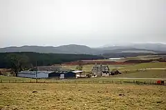
Achnahannet
| |
|---|---|
 | |
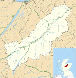 Achnahannet Location within the Badenoch and Strathspey area | |
| OS grid reference | NH977272 |
| Council area | |
| Country | Scotland |
| Sovereign state | United Kingdom |
| Postcode district | PH26 3 |
| Police | Scotland |
| Fire | Scottish |
| Ambulance | Scottish |
| UK Parliament | |
| Scottish Parliament | |
Achnahannet (Scottish Gaelic: Achadh na h-Annaid)[1] is a hamlet located northwest of Dulnain Bridge, and three and a half miles west-south-west of Grantown-on-Spey,[2] in the historical county of Morayshire, now in the Highland Council area, Scotland. Historically it belonged to the parish of Cromdale.[3]
The name, recorded as Auchnahannatt in 1589, means 'field of the mother church', from the Gaelic words achadh 'field' na h- 'of the' and annaid 'mother church, early church.[4][3] An old chapel and a well named Tobar an Domhnaich is located nearby.[3]
Geography
Achnahannet Burn flows in the area; it is a tributary of the River Dulnain.[5] The land westward from Achnahannet to Lynmore contains a belt of morainic sands and gravels between the River Dulnain terraces.[6]
Notable people
- Colonel George Grant Gordon.[7]
References
- ↑ Microsoft; Nokia (26 February 2017). "Achnahannet" (Map). Bing Maps. Microsoft. Retrieved 26 February 2017.
- ↑ Groome, Francis Hindes (1895). Ordnance gazetteer of Scotland: a survey of Scottish topography, statistical, biographical, and historical. W. Mackenzie. Retrieved 20 February 2011.
- 1 2 3 Watson, William John (1973). The history of the Celtic place-names of Scotland. Irish University Press.
- ↑ Grant, Alison (2010). Macleod, Iseabail (ed.). The Pocket Guide to Scottish Place-Names. Glasgow: Richard Drew Ltd. p. 24. ISBN 978-1-899471-00-3. OCLC 759569647.
- ↑ Reid, William (1900). Grantown and the adjacent country: a guide to Strathspey. Angus Stuart.
- ↑ Annual report. Macaulay Institute for Soil Research. 1965.
- ↑ Aberd bookeen-angus herd. 1965.