Agia Varvara
Αγία Βαρβάρα | |
|---|---|
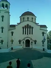 Prophet Elias church in Agia Barbara | |
 Agia Varvara Location within the region 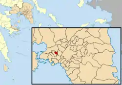 | |
| Coordinates: 38°00′N 23°39′E / 38.000°N 23.650°E | |
| Country | Greece |
| Administrative region | Attica |
| Regional unit | West Athens |
| Government | |
| • Mayor | Lampros Michos |
| Area | |
| • Municipality | 2.425 km2 (0.936 sq mi) |
| Elevation | 70 m (230 ft) |
| Population (2011)[1] | |
| • Municipality | 26,550 |
| • Municipality density | 11,000/km2 (28,000/sq mi) |
| Time zone | UTC+2 (EET) |
| • Summer (DST) | UTC+3 (EEST) |
| Postal code | 123 51 |
| Area code(s) | 210 |
| Vehicle registration | Z |
| Website | www.agiavarvara.gr |
Agia Varvara (Greek: Αγία Βαρβάρα, meaning Saint Barbara) is a suburban town in the western part of the Athens agglomeration in Attica, Greece and a municipality in the West Athens regional unit.
Geography
Agia Varvara is situated east of the mountain Aigaleo (Greek: Αιγάλεω). It is 6 km (4 mi) west of central Athens. The municipality has an area of 2.425 km2.[2] It is served by the Agia Varvara and Agia Marina stations on Line 3 of the Athens Metro.
Historical population
| Year | Population |
|---|---|
| 1981 | 29,259 |
| 1991 | 28,706 |
| 2001 | 30,562 |
| 2011 | 26,550 |
References
- ↑ "Απογραφή Πληθυσμού - Κατοικιών 2011. ΜΟΝΙΜΟΣ Πληθυσμός" (in Greek). Hellenic Statistical Authority.
- ↑ "Population & housing census 2001 (incl. area and average elevation)" (PDF) (in Greek). National Statistical Service of Greece. Archived from the original (PDF) on 2015-09-21.
Places adjacent to Agia Varvara | ||||||||||||||||
|---|---|---|---|---|---|---|---|---|---|---|---|---|---|---|---|---|
| ||||||||||||||||
Administrative division of the Attica Region | ||
|---|---|---|
| Regional unit of Central Athens | 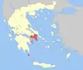 | |
| Regional unit of North Athens | ||
| Regional unit of West Athens | ||
| Regional unit of South Athens | ||
| Regional unit of Piraeus | ||
| Regional unit of East Attica | ||
| Regional unit of West Attica | ||
| Regional unit of Islands | ||
| ||
This article is issued from Wikipedia. The text is licensed under Creative Commons - Attribution - Sharealike. Additional terms may apply for the media files.