Ahuachapán | |
|---|---|
 | |
 Flag  Coat of arms | |
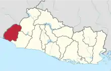 Location within El Salvador | |
| Coordinates: 13°52′01″N 89°53′31″W / 13.867°N 89.892°W | |
| Country | |
| Created | 1869 |
| Seat | Ahuachapán |
| Area | |
| • Total | 1,239.6 km2 (478.6 sq mi) |
| • Rank | Ranked 8th |
| Population | |
| • Total | 333,406 |
| • Rank | Ranked 7th |
| • Density | 270/km2 (700/sq mi) |
| Time zone | UTC−6 (CST) |
| ISO 3166 code | SV-AH |
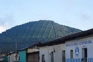
Ahuachapán (Spanish pronunciation: [awatʃaˈpan]) is a department of El Salvador in the west of the country.[1] The capital is Ahuachapán.[2] In the South it has the Apaneca-Ilamatepec Range and the Cerro Grande de Apaneca (Apaneca Grand Hill).[1] Its has a population of over 360,000 people.[1] The Ahuachapán Department was created by the Legislative Decree of February 9, 1869 under the administration of Francisco Dueñas.
Municipalities
References
- 1 2 3 Perez, Orlando J. (2016-07-26). Historical Dictionary of El Salvador. Rowman & Littlefield. p. 22. ISBN 978-0-8108-8020-7.
- ↑ Cohen, Saul Bernard (2008). The Columbia Gazetteer of the World: A to G. Columbia University Press. p. 39. ISBN 978-0-231-14554-1.
This article is issued from Wikipedia. The text is licensed under Creative Commons - Attribution - Sharealike. Additional terms may apply for the media files.