Almirante Brown
Partido de Almirante Brown | |
|---|---|
 Logo | |
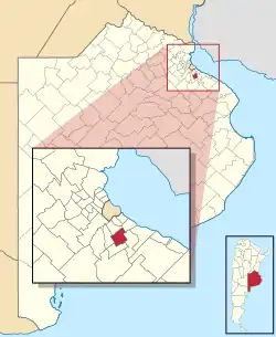 Almirante Brown location in Gran Buenos Aires | |
| Coordinates: 34°47′S 58°24′W / 34.783°S 58.400°W | |
| Country | |
| Province | |
| Established | 1873 |
| Founded by | provincial law |
| Seat | Adrogué |
| Government | |
| • Mayor | Mariano Cascallares (Front for Victory) |
| Area | |
| • Total | 129.33 km2 (49.93 sq mi) |
| Population | |
| • Total | 555,731 |
| • Density | 4,300/km2 (11,000/sq mi) |
| Demonym | brownense |
| Postal Code | B1846 |
| IFAM | |
| Area Code | 011 |
| Website | www |
Almirante Brown is a partido of the Buenos Aires Province, Argentina, located at the south of the Gran Buenos Aires urban area, at coordinates 34°47′S 58°24′W / 34.783°S 58.400°W.
It has an area of 129.33 km2 (49.9 sq mi) and 555,731 inhabitants (2010 census [INDEC]),[1] and its capital is Adrogué.
Name
The partido is named after Irish-born General William Brown who led the Argentine navy in the Argentine War of Independence and helped the country gain its independence from the Spanish Empire.
Cities
- Adrogué
- Burzaco
- Claypole
- Don Orione
- Rafael Calzada
- Glew
- Longchamps
- Malvinas Argentinas
- José Marmol
- Ministro Rivadavia
- San Francisco de Asís
- San José
- San Francisco Solano
References
- 1 2 "2010 Census provisional results". Archived from the original on 2012-09-01. Retrieved 2011-03-07.
External links
Wikimedia Commons has media related to Almirante Brown Partido.
This article is issued from Wikipedia. The text is licensed under Creative Commons - Attribution - Sharealike. Additional terms may apply for the media files.