Andriba | |
|---|---|
 Andriba Location in Madagascar | |
| Coordinates: 17°35′S 46°56′E / 17.583°S 46.933°E | |
| Country | |
| Region | Betsiboka |
| District | Maevatanana |
| Elevation | 633 m (2,077 ft) |
| Population (2001)[2] | |
| • Total | 32,000 |
| Time zone | UTC3 (EAT) |
| Postal code | 412 |
Andriba is a municipality in Madagascar. It belongs to the district of Maevatanana, which is a part of Betsiboka Region. The population of the commune was estimated to be approximately 32,000 in 2001 commune census.[2]
Primary and junior level secondary education are available in town. The majority 70% of the population of the commune are farmers, while an additional 25% receives their livelihood from raising livestock. The most important crops are rice and raffia palm, while other important agricultural products are cassava and bambara groundnut. Services provide employment for 5% of the population.[2]
History
On 20 August 1895 French invasion forces approached the town of Andriba that was taken on the following day, after brief combats with the Hova defenders.[3]
References
- ↑ Estimated based on DEM data from Shuttle Radar Topography Mission
- 1 2 3 "ILO census data". Cornell University. 2002. Retrieved 2008-03-05.
- ↑ La prise d'Andriba
Capital: Maevatanana | ||
| Kandreho (7) - 411 | 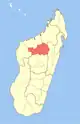 | |
| Maevatanana (20) - 412 | ||
| Tsaratanana (13) - 421 | ||
3 districts; 32 communes | ||
17°35′S 46°56′E / 17.583°S 46.933°E