Anjahambe | |
|---|---|
 Anjahambe Location in Madagascar | |
| Coordinates: 17°23′S 49°8′E / 17.383°S 49.133°E | |
| Country | |
| Region | Analanjirofo |
| District | Vavatenina |
| Government | |
| • Maire | Isidore Ratovoarison |
| Area | |
| • Total | 81 km2 (31 sq mi) |
| Elevation | 176 m (577 ft) |
| Population (2014) | |
| • Total | 12,498 |
| Time zone | UTC3 (EAT) |
| Postal code | 518 |
Anjahambe is a municipality in Madagascar. It belongs to the district of Vavatenina, which is a part of Analanjirofo Region. The population of the commune was 12498 in 2014.
Primary and junior level secondary education are available in town. The majority 90% of the population of the commune are farmers, while an additional 5% receives their livelihood from raising livestock. The most important crops are rice and bananas, while other important agricultural products are coffee, cloves and vanilla. Services provide employment for 5% of the population.[3]
Roads
Anjahambe is situated at 17km from Vavatenina on the RN 22 to Fenoarivo Atsinanana (Fénérive) (53km to the National road 5). It lies at the Maningory River.
References
- ↑ PCDEA de la commune
- ↑ Estimated based on DEM data from Shuttle Radar Topography Mission
- ↑ "ILO census data". Cornell University. 2002. Retrieved 2008-03-08.
Capital: Fenoarivo Atsinanana | ||
| Fenerive Est (509) | 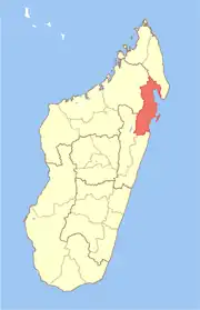 | |
| Mananara Nord (511) | ||
| Maroantsetra (512) | ||
| Sainte Marie (Nosy Boraha) (515) | ||
| Soanierana Ivongo (516) | ||
| Vavatenina (518) | ||
6 districts; 71 communes | ||
17°23′S 49°8′E / 17.383°S 49.133°E