Aperibé | |
|---|---|
Municipality | |
| Município de Aperibé | |
 Flag  Seal | |
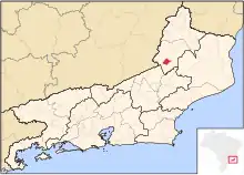 Location of Aperibé in the state of Rio de Janeiro | |
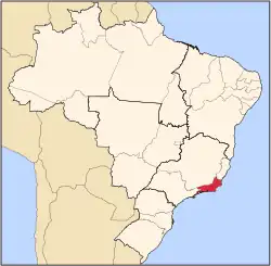
 Aperibé Location of Aperibé in Brazil | |
| Coordinates: 21°37′15″S 42°06′10″W / 21.62083°S 42.10278°W | |
| Country | |
| Region | Southeast |
| State | |
| Government | |
| • Prefeito | Ronald de Cássio Daibes Moreira (PSD) |
| Area | |
| • Total | 88.780 km2 (34.278 sq mi) |
| Elevation | 221 m (725 ft) |
| Population (2020 [1]) | |
| • Total | 11,901 |
| Time zone | UTC-3 (UTC-3) |
| Website | |
Aperibé (Portuguese pronunciation: [ɐpeɾiˈbɛ], [apɛɾiˈbɛ]) is a municipality located in the Brazilian state of Rio de Janeiro. Its population was 11,901 (2020) and its area is 89 km².[2]
Location of Aperibé within Rio de Janeiro state
References
- ↑ IBGE 2020
- ↑ IBGE - "Archived copy". Archived from the original on 2008-06-11. Retrieved 2008-06-11.
{{cite web}}: CS1 maint: archived copy as title (link)
Capital: Rio de Janeiro | |||||||||||
| Mesoregion Baixadas |
|  | |||||||||
| Mesoregion Centro Fluminense |
| ||||||||||
| Mesoregion Metropolitana do Rio de Janeiro |
| ||||||||||
| Mesoregion Noroeste Fluminense |
| ||||||||||
| Mesoregion Norte Fluminense |
| ||||||||||
| Mesoregion Sul Fluminense |
| ||||||||||
This article is issued from Wikipedia. The text is licensed under Creative Commons - Attribution - Sharealike. Additional terms may apply for the media files.