Arravonitsa
Αρραβωνίτσα | |
|---|---|
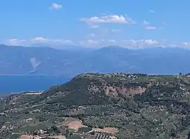 The plateau and the village of Arravonitsa as seen from Myrovrysi. | |
 Arravonitsa | |
| Coordinates: 38°15′N 21°58′E / 38.250°N 21.967°E | |
| Country | Greece |
| Administrative region | West Greece |
| Regional unit | Achaea |
| Municipality | Aigialeia |
| Municipal unit | Erineos |
| City established | x |
| Village established | before 1692 [1] |
| Districts | 5 |
| Highest elevation | 500 m (1,600 ft) |
| Lowest elevation | 100 m (300 ft) |
| Population (2011)[2] | |
| • Rural | 166 |
| Community | |
| • Population | 189 (2011) |
| Time zone | UTC+2 (EET) |
| • Summer (DST) | UTC+3 (EEST) |
| Postal code | 251 00 |
| Area code(s) | 2691 |
| Vehicle registration | AX |
Arravonitsa (Greek: Αρραβωνίτσα) is a village and a community in the municipal unit of Erineos, Achaea, Greece. It is located in a hilly area, 15 km west of Aigio. The community consists of the villages Arravonitsa and Synania. In 2001 Arravonitsa had a population of 166 for the village and 189 for the community.
Population
| Year | Population |
|---|---|
| 1981 | 361 |
| 1991 | 362 |
| 2001 | 263 |
| 2011 | 189 |
See also
References
- ↑ "Αρραβωνίτσα Αχαΐας: Ιστορία/History".
- 1 2 "Απογραφή Πληθυσμού - Κατοικιών 2011. ΜΟΝΙΜΟΣ Πληθυσμός" (in Greek). Hellenic Statistical Authority.
External links
This article is issued from Wikipedia. The text is licensed under Creative Commons - Attribution - Sharealike. Additional terms may apply for the media files.