| Auchintaple Loch | |
|---|---|
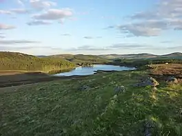 A view of the loch from The Knaps in Angus | |
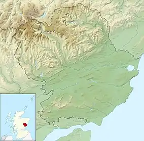 Auchintaple Loch Location in Angus | |
| Location | NO19656476 |
| Coordinates | 56°46′03″N 3°19′00″W / 56.76739883°N 3.31668934°W |
| Type | freshwater loch |
| Primary outflows | Allt na Beinne into River Isla |
| Max. length | 0.5310 km (0.3299 mi)[1] |
| Max. width | 0.4023 km (0.2500 mi)[1] |
| Surface area | 13 ha (32 acres)[2] |
| Average depth | 15 ft (4.6 m)[1] |
| Max. depth | 17 ft (5.2 m)[1] |
| Water volume | 23,966,484 cu ft (678,655.3 m3)[1] |
| Shore length1 | 2 km (1.2 mi) [2] |
| Surface elevation | 356 m (1,168 ft)[2] |
| Max. temperature | 58.0 °F (14.4 °C) |
| Min. temperature | 57.5 °F (14.2 °C) |
| Islands | 0 |
| 1 Shore length is not a well-defined measure. | |
Auchintaple Loch also known as Auchenchapel Loch, is a small shallow freshwater loch that is located in Glen Isla in Angus, Scotland.[1][2]
See also
References
- 1 2 3 4 5 6 John, Murray; Lawrence, Pullar. Bathymetrical Survey of the Fresh-Water Lochs of Scotland, 1897–1909 Lochs of the Tay Basin Volume II – Auchenchapel Loch. National Library of Scotland. p. 122. Retrieved 6 December 2020.
 This article incorporates text from this source, which is in the public domain.
 - 1 2 3 4 "Auchintaple Loch". Centre for Ecology and Hydrology. Scotland and Northern Ireland Forum for Environmental Research (SNIFFER). Archived from the original on 11 June 2016. Retrieved 6 December 2020.
This article is issued from Wikipedia. The text is licensed under Creative Commons - Attribution - Sharealike. Additional terms may apply for the media files.