Autruche | |
|---|---|
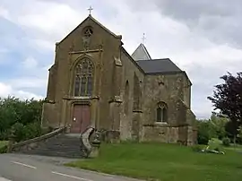 The church in Autruche | |
.svg.png.webp) Coat of arms | |
Location of Autruche | |
 Autruche  Autruche | |
| Coordinates: 49°27′19″N 4°54′01″E / 49.4553°N 4.9003°E | |
| Country | France |
| Region | Grand Est |
| Department | Ardennes |
| Arrondissement | Vouziers |
| Canton | Vouziers |
| Intercommunality | CC Argonne Ardennaise |
| Government | |
| • Mayor (2020–2026) | Anne Sembeni[1] |
| Area 1 | 8.24 km2 (3.18 sq mi) |
| Population | 53 |
| • Density | 6.4/km2 (17/sq mi) |
| Time zone | UTC+01:00 (CET) |
| • Summer (DST) | UTC+02:00 (CEST) |
| INSEE/Postal code | 08035 /08240 |
| Elevation | 166–242 m (545–794 ft) (avg. 186 m or 610 ft) |
| 1 French Land Register data, which excludes lakes, ponds, glaciers > 1 km2 (0.386 sq mi or 247 acres) and river estuaries. | |
Autruche (French pronunciation: [otʁyʃ] ⓘ) is a commune in the Ardennes department in the Grand Est region of northern France.
The inhabitants of the commune are known as Autruchiens or Autruchiennes.[3]
Geography
Autruche is located some 43 km east by south-east of Rethel and 20 km north-east of Vouziers. Access to the commune is by the D947 from Germont in the south-west which passes through the southern corner of the commune and continues east to Bar-lès-Buzancy. The D12 also comes from Authe in the north-west and joins the D947 in the commune. Access to the village is by a local road branching from the D947 which goes north to the village. The commune is entirely farmland except for some lakes in the south.[4]
The Bar river forms the southern border of the commune as it flows west then follows the Canal des Ardennes to eventually join the Meuse at Vrigne-Meuse. The Ruisseau de Saint Pierremont flows from the north of the commune towards the south-west and continues to join the Bar west of the commune. The Ruisseau du Clageot rises in the north of the commune and flows south-west down the centre of the commune and also joins the Bar on the southern border.[4]
Neighbouring communes and villages
Places adjacent to Autruche | |
|---|---|
Heraldry
Arms of Autruche |
The official status of the blazon remains to be determined.
Blazon:
|
Administration
List of Successive Mayors[5]
| From | To | Name |
|---|---|---|
| 1995 | 2014 | Claude Lambert |
| 2014 | current | Anne Sembeni |
Demography
In 2017 the commune had 69 inhabitants.
|
| ||||||||||||||||||||||||||||||||||||||||||||||||||||||||||||||||||||||||||||||||||||||||||||||||||||||||||||
| Source: EHESS[6] and INSEE[7] | |||||||||||||||||||||||||||||||||||||||||||||||||||||||||||||||||||||||||||||||||||||||||||||||||||||||||||||
Sites and monuments
The Church of Saint-Nicolas (16th century)![]() is registered as an historical monument.[8] The church contains two items that are registered as historical objects:
is registered as an historical monument.[8] The church contains two items that are registered as historical objects:
See also
References
- ↑ "Répertoire national des élus: les maires". data.gouv.fr, Plateforme ouverte des données publiques françaises (in French). 2 December 2020.
- ↑ "Populations légales 2021". The National Institute of Statistics and Economic Studies. 28 December 2023.
- ↑ Inhabitants of Ardennes (in French)
- 1 2 3 Google Maps
- ↑ List of Mayors of France (in French)
- ↑ Des villages de Cassini aux communes d'aujourd'hui: Commune data sheet Autruche, EHESS (in French).
- ↑ Population en historique depuis 1968, INSEE
- ↑ Ministry of Culture, Mérimée PA00078337 Church of Saint-Nicolas (in French)

- ↑ Ministry of Culture, Palissy PM08000038 6 Statuettes (in French)
- ↑ Ministry of Culture, Palissy PM08000037 Sculpture: Triumphant Virgin (in French)
External links
- Autruche on the old IGN website (in French)
- Autruche on Géoportail, National Geographic Institute (IGN) website (in French)
- Autruche on the 1750 Cassini Map