Bad Kohlgrub | |
|---|---|
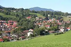 Bad Kohlgrub from the northeast | |
 Coat of arms | |
Location of Bad Kohlgrub within Garmisch-Partenkirchen district 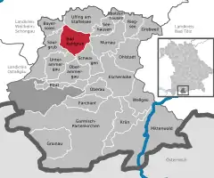 | |
 Bad Kohlgrub  Bad Kohlgrub | |
| Coordinates: 47°40′N 11°03′E / 47.667°N 11.050°E | |
| Country | Germany |
| State | Bavaria |
| Admin. region | Oberbayern |
| District | Garmisch-Partenkirchen |
| Government | |
| • Mayor (2018–24) | Franz Degele[1] (FW) |
| Area | |
| • Total | 32.66 km2 (12.61 sq mi) |
| Elevation | 828 m (2,717 ft) |
| Population (2022-12-31)[2] | |
| • Total | 2,869 |
| • Density | 88/km2 (230/sq mi) |
| Time zone | UTC+01:00 (CET) |
| • Summer (DST) | UTC+02:00 (CEST) |
| Postal codes | 82433 |
| Dialling codes | 08845 |
| Vehicle registration | GAP |
| Website | www.bad-kohlgrub.de |
Bad Kohlgrub is a German municipality in the district of Garmisch-Partenkirchen, in Bavaria. It lies 12 kilometres (7.5 mi) west of Murnau am Staffelsee and 8 kilometres (5.0 mi) north of Oberammergau, and is connected to both by the Ammergau Railway.
Skiing facilities include 4 ski lifts, 4 pistes and 30 kilometres (19 mi) of cross-country skiing trails.[3] A chairlift (opened 1954[4]) south of the town leads up to the Hörnlehütte below the summit of the Hörnle mountain (1,547 metres/5,075 ft).[5]
Transport
The municipality has two railway stations, Bad Kohlgrub and Bad Kohlgrub Kurhaus, on the Ammergau Railway.
References
Wikimedia Commons has media related to Bad Kohlgrub.
Wikivoyage has a travel guide for Bad Kohlgrub.
- ↑ Liste der ersten Bürgermeister/Oberbürgermeister in kreisangehörigen Gemeinden, Bayerisches Landesamt für Statistik, accessed 19 July 2021.
- ↑ Genesis Online-Datenbank des Bayerischen Landesamtes für Statistik Tabelle 12411-003r Fortschreibung des Bevölkerungsstandes: Gemeinden, Stichtag (Einwohnerzahlen auf Grundlage des Zensus 2011)
- ↑ "Bad Kohlgrub Ski Resort Guide". snow-forecast.com. Retrieved 1 September 2012.
- ↑ "Hörnle chairlift". Ammergauer Alpen GmbH. Archived from the original on 10 February 2013. Retrieved 1 September 2012.
- ↑ BY 7: Ammergebirge Ost, Pürschling. Hörnle (Map). 1:25000. Alpenvereinskarte Bayerische Alpen. Deutscher Alpenverein. 2009.
Towns and municipalities in Garmisch-Partenkirchen (district) | ||
|---|---|---|
Coat of Arms of Garmisch-Partenkirchen district | ||
This article is issued from Wikipedia. The text is licensed under Creative Commons - Attribution - Sharealike. Additional terms may apply for the media files.