Bakarac | |
|---|---|
Village | |
 Bakarac | |
| Coordinates: 45°16′48″N 14°34′53″E / 45.279869°N 14.581475°E | |
| Country | |
| Region | Croatian Littoral |
| County | Primorje-Gorski Kotar County |
| City | Kraljevica |
| Area | |
| • Total | 0.6 sq mi (1.6 km2) |
| Elevation | 10 ft (3 m) |
| Population (2021)[2] | |
| • Total | 287 |
| • Density | 460/sq mi (180/km2) |
| Time zone | UTC+1 (CET) |
| • Summer (DST) | UTC+2 (CEST) |
| Postal code | 51261 |
| Area code | 051 |
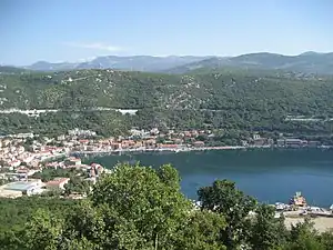
Bakarac (Italian: Buccarizza) is a village in Bay of Bakar, Croatia. The settlement is administered as a part of the City of Kraljevica and Primorje-Gorski Kotar County. According to the 2001 census, it has 307 inhabitants.[3] It is connected by the D8 state road.
Bakarac
Sources
Wikimedia Commons has media related to Bakarac.
- ↑ Register of spatial units of the State Geodetic Administration of the Republic of Croatia. Wikidata Q119585703.
- ↑ "Population by Age and Sex, by Settlements, 2021 Census". Census of Population, Households and Dwellings in 2021. Zagreb: Croatian Bureau of Statistics. 2022.
- ↑ "2001 census by settlement". Central Bureau of Statistics (Croatia) (in Croatian). March 31, 2001.
This article is issued from Wikipedia. The text is licensed under Creative Commons - Attribution - Sharealike. Additional terms may apply for the media files.