Balaruc-les-Bains | |
|---|---|
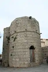 Church ND d'Aix | |
.svg.png.webp) Coat of arms | |
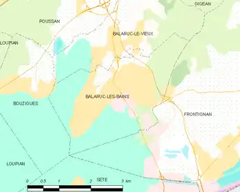
Location of Balaruc-les-Bains | |
 Balaruc-les-Bains  Balaruc-les-Bains | |
| Coordinates: 43°26′30″N 3°40′40″E / 43.4417°N 3.6778°E | |
| Country | France |
| Region | Occitania |
| Department | Hérault |
| Arrondissement | Montpellier |
| Canton | Frontignan |
| Intercommunality | CA Sète Agglopôle Méditerranée |
| Government | |
| • Mayor (2020–2026) | Gérard Canovas[1] |
| Area 1 | 8.66 km2 (3.34 sq mi) |
| Population | 7,073 |
| • Density | 820/km2 (2,100/sq mi) |
| Time zone | UTC+01:00 (CET) |
| • Summer (DST) | UTC+02:00 (CEST) |
| INSEE/Postal code | 34023 /34540 |
| Elevation | 0–169 m (0–554 ft) (avg. 3 m or 9.8 ft) |
| 1 French Land Register data, which excludes lakes, ponds, glaciers > 1 km2 (0.386 sq mi or 247 acres) and river estuaries. | |
Balaruc-les-Bains (French pronunciation: [balaʁyk le bɛ̃]; Occitan: Los Banhs de Balaruc) is a commune in the Hérault department in the Occitanie region in southern France.
Population
| Year | Pop. | ±% p.a. |
|---|---|---|
| 1968 | 1,830 | — |
| 1975 | 2,957 | +7.10% |
| 1982 | 4,369 | +5.73% |
| 1990 | 5,013 | +1.73% |
| 1999 | 5,688 | +1.41% |
| 2007 | 6,130 | +0.94% |
| 2012 | 6,886 | +2.35% |
| 2017 | 6,751 | −0.40% |
| Source: INSEE[3] | ||
Map
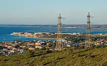
From La Gardiole Mountain.
See also
References
- ↑ "Répertoire national des élus: les maires". data.gouv.fr, Plateforme ouverte des données publiques françaises (in French). 2 December 2020.
- ↑ "Populations légales 2021". The National Institute of Statistics and Economic Studies. 28 December 2023.
- ↑ Population en historique depuis 1968, INSEE
Wikimedia Commons has media related to Balaruc-les-Bains.
This article is issued from Wikipedia. The text is licensed under Creative Commons - Attribution - Sharealike. Additional terms may apply for the media files.