Bansko Municipality
Община Банско | |
|---|---|
Municipality (Obshtina) | |
 Coat of arms | |
.png.webp) Location in Blagoevgrad province Location on map of Bulgaria 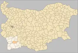 | |
| Coordinates: 41°50′N 23°29′E / 41.833°N 23.483°E | |
| Country | Bulgaria |
| Province (Oblast) | Blagoevgrad |
| Seat | Bansko |
| Area | |
| • Total | 475.88 km2 (183.74 sq mi) |
| Elevation | 871 m (2,858 ft) |
| Population (2011 census) | |
| • Total | 13,088 |
| • Density | 28/km2 (71/sq mi) |
| Time zone | UTC+2 (EET) |
| • Summer (DST) | UTC+3 (EEST) |
| Postal code | 2770 |
| Area code | 07443 |
| Website | www |
Bansko Municipality (Bulgarian: Община Банско, romanized: Obshtina Bansko) is situated in southwestern Bulgaria and is one of the municipalities of Blagoevgrad Province.
Settlements
| Town/Village | Area (km²) | Population |
|---|---|---|
| Bansko (Банско) | 148.280 | 8,911 |
| Dobrinishte (Добринище) | 80.356 | 2,843 |
| Filipovo (Филипово) | 15.157 | 597 |
| Gostun (Гостун) | 52.425 | 75 |
| Kremen (Кремен) | 61.869 | 299 |
| Mesta (Места) | 16.259 | 274 |
| Obidim (Обидим) | 64.962 | 142 |
| Osenovo (Осеново) | 52.832 | 114 |
| Total | 492.14 | 13,255 |
Demographics
Religion
According to the latest Bulgarian census of 2011, the religious composition, among those who answered the optional question on religious identification, was the following:
References
- ↑ "Religious composition of Bulgaria 2011". pop-stat.mashke.org.
External links
![]() Media related to Bansko Municipality at Wikimedia Commons
Media related to Bansko Municipality at Wikimedia Commons
- Bansko municipality website (in Bulgarian and English)
- Pictures and images from Bansko Ski Resort Archived 2018-12-06 at the Wayback Machine
- Bansko Municipality at Curlie
Capital: Bansko | ||
| Towns/Villages |  | |
| Landmarks | ||
| Culture |
| |
| Notable people | ||
This article is issued from Wikipedia. The text is licensed under Creative Commons - Attribution - Sharealike. Additional terms may apply for the media files.