| Barguzin Range | |
|---|---|
| Russian: Баргузинский хребет | |
 | |
| Highest point | |
| Peak | Baikal Peak |
| Elevation | 2,840 m (9,320 ft) |
| Geography | |
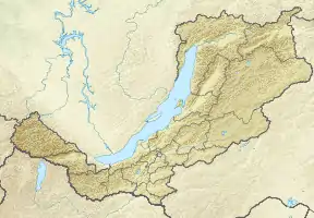 Location in Buryatia, Russia | |
| Country | Russia |
| Federal subject | Buryatia |
| Range coordinates | 54°42′N 110°24′E / 54.700°N 110.400°E |
| Parent range | South Siberian System |
| Geology | |
| Age of rock | Upper Proterozoic |
| Type of rock | Granite, shale |
| Climbing | |
| Easiest route | From Ulan-Ude |
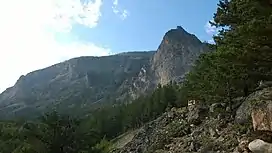
Barguzin Range (Russian: Баргузинский хребет) is a range in Buryatia, Russia along the northeastern shore of Baikal.[1]
Its length is 280 km, height up to 2,840 m. It is mostly covered by larch taiga. The range bounds the Barguzin Valley on the northwest. A part of the Barguzin Nature Reserve is located on the western slopes of the range.
See also
References
- ↑ Kozhov, M. (2013-11-11). Lake Baikal and Its Life. Springer Science & Business Media. p. 9. ISBN 9789401573887.
This article is issued from Wikipedia. The text is licensed under Creative Commons - Attribution - Sharealike. Additional terms may apply for the media files.