Barnes Lake, Michigan | |
|---|---|
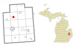 Location within Lapeer County | |
 Barnes Lake Location within the state of Michigan  Barnes Lake Location within the United States | |
| Coordinates: 43°10′45″N 83°18′00″W / 43.17917°N 83.30000°W | |
| Country | United States |
| State | Michigan |
| County | Lapeer |
| Township | Deerfield |
| Area | |
| • Total | 1.82 sq mi (4.72 km2) |
| • Land | 1.55 sq mi (4.01 km2) |
| • Water | 0.27 sq mi (0.71 km2) |
| Elevation | 788 ft (240 m) |
| Population (2020) | |
| • Total | 768 |
| • Density | 495.48/sq mi (191.58/km2) |
| Time zone | UTC-5 (Eastern (EST)) |
| • Summer (DST) | UTC-4 (EDT) |
| ZIP code(s) | |
| Area code | 810 |
| FIPS code | 26-05466 |
| GNIS feature ID | 2804667[2] |
Barnes Lake is a census-designated place (CDP) in the northwest part of Deerfield Township, Lapeer County, Michigan, United States, surrounding a lake of the same name. It is bordered to the west by the CDP of Millers Lake. M-24 forms the border between the two CDPs; the state highway leads north 12 miles (19 km) to Mayville and south 9 miles (14 km) to Lapeer.
Barnes Lake was first listed as a CDP prior to the 2020 census.[2] Previously, the community was part of the Barnes Lake-Millers Lake CDP.
Demographics
| Census | Pop. | Note | %± |
|---|---|---|---|
| 2020 | 768 | — | |
| U.S. Decennial Census[3] | |||
References
- ↑ "2020 U.S. Gazetteer Files". United States Census Bureau. Retrieved May 21, 2022.
- 1 2 3 U.S. Geological Survey Geographic Names Information System: Barnes Lake Census Designated Place
- ↑ "Census of Population and Housing". Census.gov. Retrieved June 4, 2016.
Municipalities and communities of Lapeer County, Michigan, United States | ||
|---|---|---|
| Cities | 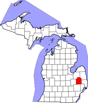 Map of Michigan highlighting Lapeer County.svg | |
| Villages | ||
| Civil townships | ||
| CDPs | ||
| Other communities | ||
| Footnotes | ‡This populated place also has portions in an adjacent county or counties | |
This article is issued from Wikipedia. The text is licensed under Creative Commons - Attribution - Sharealike. Additional terms may apply for the media files.