Biharkeresztes | |
|---|---|
 | |
 Flag  Coat of arms | |
 Biharkeresztes | |
| Coordinates: 47°08′N 21°43′E / 47.133°N 21.717°E | |
| Country | |
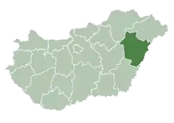
| County | Hajdú-Bihar |
| District | Berettyóújfalu |
| Area | |
| • Total | 49.26 km2 (19.02 sq mi) |
| Population (2015) | |
| • Total | 4,149[1] |
| • Density | 84.3/km2 (218/sq mi) |
| Time zone | UTC+1 (CET) |
| • Summer (DST) | UTC+2 (CEST) |
| Postal code | 4110 |
| Area code | (+36) 54 |
| Website | www |
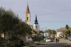
Biharkeresztes is a town in Hajdú-Bihar county, in the Northern Great Plain region of eastern Hungary.
Geography
It covers an area of 49.26 km2 (19 sq mi) and has a population of 4149 people (2015).[1]
References
- 1 2 Gazetteer of Hungary, 1 January 2015. Hungarian Central Statistical Office. 3 September 2015
External links
Wikimedia Commons has media related to Biharkeresztes.
- Official website in Hungarian
| Towns (3) |
| |
|---|---|---|
| Large villages (2) | ||
| Villages (20) | ||
| City with county rights |
|   |
|---|---|---|
| Towns | ||
| Large villages | ||
| Villages |
| |
| Other topics |
| |
47°08′N 21°43′E / 47.133°N 21.717°E
This article is issued from Wikipedia. The text is licensed under Creative Commons - Attribution - Sharealike. Additional terms may apply for the media files.