Biritiba Mirim | |
|---|---|
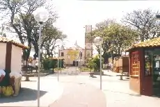 Biritiba Mirim plaza | |
 Flag _-_Brasao.svg.png.webp) Coat of arms | |
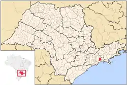 Location of Biritiba Mirim | |
 Biritiba Mirim | |
| Coordinates: 23°34′22″S 46°02′20″W / 23.57278°S 46.03889°W | |
| Country | |
| Region | Southeast |
| State | |
| Metropolitan Region | São Paulo |
| Government | |
| • Mayor | Walter Hideki Tajiri (PTB) |
| Area | |
| • Total | 317.41 km2 (122.55 sq mi) |
| Population (2020 [1]) | |
| • Total | 32,936 |
| • Density | 86.77/km2 (224.7/sq mi) |
| Time zone | UTC−3 (BRT) |
| HDI (2000) | 0,750 – medium |
| Website | Biritiba Mirim |
Biritiba Mirim is a Brazilian municipality of the state of São Paulo. It is part of the Metropolitan Region of São Paulo.[2] The population is 32,936 (2020 est.) in an area of 317.41 km².[3] Its limits are Guararema in the north, Salesópolis in the east, Bertioga to the south and Mogi das Cruzes in the west and northwest.
References
- ↑ IBGE 2020
- ↑ "Lei Complementar nº 1.139, de 16 de junho de 2011". Archived from the original on 2015-10-01. Retrieved 2015-09-30.
- ↑ Instituto Brasileiro de Geografia e Estatística
External links
- (in Portuguese) Biritiba Mirim Official Site
This article is issued from Wikipedia. The text is licensed under Creative Commons - Attribution - Sharealike. Additional terms may apply for the media files.