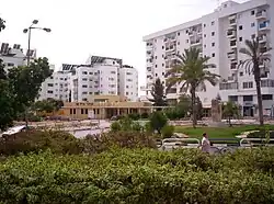
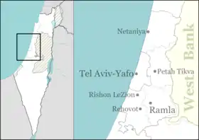
Bnei Ayish
| |
|---|---|
Local council (from 1981) | |
| Hebrew transcription(s) | |
| • ISO 259 | Bnei ʕayš |
| • Also spelled | Bene Ayish (official) |
 | |
 Bnei Ayish | |
| Coordinates: 31°47′18.94″N 34°45′39.29″E / 31.7885944°N 34.7609139°E | |
| District | Central |
| Founded | 7 October 1957 |
| Government | |
| • Head of Municipality | Aryeh Garela |
| Area | |
| • Total | 836 dunams (83.6 ha or 207 acres) |
| Population (2021)[1] | |
| • Total | 6,895 |
| • Density | 8,200/km2 (21,000/sq mi) |
| Name meaning | Sons of Akiva Yosef Schlezinger |
Bnei Ayish (Hebrew: בְּנֵי עַיִ"שׁ) is a town and local council in the Central District of Israel. Located around ten kilometers from Ashdod and adjacent to Gedera, it had a population of 6,895 in 2021.[1]
History
The town was founded in 1957 on land that had belonged to the depopulated Palestinian village of Yasur.[2] Before 1948, the area had served as a military base for British Army troops during the Mandate era. It was named after Rabbi Akiva Yosef Schlezinger, whose name is abbreviated to Ayish.
Bnei Ayish originally served as a transit camp for immigrants from Yemen in the early 1950s. Today its population is almost entirely made up of Jews of Yemenite descent and immigrants from the former Soviet Union .
References
- 1 2 "Regional Statistics". Israel Central Bureau of Statistics. Retrieved 22 February 2023.
- ↑ Khalidi, Walid (1992), All That Remains: The Palestinian Villages Occupied and Depopulated by Israel in 1948, Washington D.C.: Institute for Palestine Studies, p. 139, ISBN 0-88728-224-5
External links
- Local council website
 Media related to Bnei Ayish at Wikimedia Commons

This article is issued from Wikipedia. The text is licensed under Creative Commons - Attribution - Sharealike. Additional terms may apply for the media files.