Bordj Bou Arreridj District | |
|---|---|
 | |
| Coordinates: 36°4′52.4″N 4°46′4.9″E / 36.081222°N 4.768028°E | |
| Country | |
| Province | Bordj Bou Arréridj Province |
| Capital | Bordj Bou Arreridj |
| Area | |
| • Total | 31 sq mi (81 km2) |
| Population (2008) | |
| • Total | 168,346 |
| • Density | 5,380/sq mi (2,078/km2) |
| Time zone | UTC+1 (CET) |
The Bordj Bou Arreridj district is an Algerian administrative district in the Bordj Bou Arreridj province. Its chief town is located on the eponymous town of Bordj Bou Arreridj.[1][2]
Location
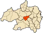
The Bordj Bou Arreridj district is located in the center of the Bordj Bou Arreridj province.
Communes
The district is composed of only one commune: Bordj Bou Arreridj.
References
- ↑ "Bordj Bou Arreridj District". OpenStreetMap. OpenStreetMap. Retrieved 13 May 2018.
- ↑ "Distance from London to Wilaya-De-Bordj-Bou-Arréridj". Distance Calculator. Retrieved 13 May 2018.
.svg.png.webp)
This article is issued from Wikipedia. The text is licensed under Creative Commons - Attribution - Sharealike. Additional terms may apply for the media files.