Boretto | |
|---|---|
| Comune di Boretto | |
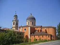 Parish church of San Marco. | |
Location of Boretto | |
 Boretto Location of Boretto in Italy 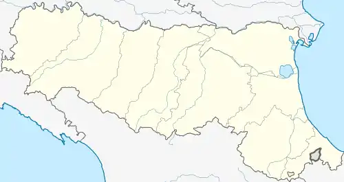 Boretto Boretto (Emilia-Romagna) | |
| Coordinates: 44°54′N 10°33′E / 44.900°N 10.550°E | |
| Country | Italy |
| Region | Emilia-Romagna |
| Province | Reggio Emilia (RE) |
| Government | |
| • Mayor | Matteo Benassi |
| Area | |
| • Total | 19.2 km2 (7.4 sq mi) |
| Elevation | 23 m (75 ft) |
| Population (31 December 2016)[2] | |
| • Total | 5,293 |
| • Density | 280/km2 (710/sq mi) |
| Demonym | Borettesi |
| Time zone | UTC+1 (CET) |
| • Summer (DST) | UTC+2 (CEST) |
| Postal code | 42022 |
| Dialing code | 0522 |
| Website | Official website |
Boretto (Reggiano: Borèt) is a comune (municipality) in the Province of Reggio Emilia in the Italian region Emilia-Romagna, located about 80 kilometres (50 mi) northwest of Bologna and about 25 kilometres (16 mi) northwest of Reggio Emilia..
Boretto borders the following municipalities: Brescello, Castelnovo di Sotto, Gualtieri, Pomponesco, Poviglio, Viadana.
Among the churches is the Basilica Minore of San Marco and Santa Croce.
External links
References
- ↑ "Superficie di Comuni Province e Regioni italiane al 9 ottobre 2011". Italian National Institute of Statistics. Retrieved 16 March 2019.
- ↑ All demographics and other statistics: Italian statistical institute Istat.
This article is issued from Wikipedia. The text is licensed under Creative Commons - Attribution - Sharealike. Additional terms may apply for the media files.