Borzonasca | |
|---|---|
| Comune di Borzonasca | |
 Borzonasca | |
 Coat of arms | |
Location of Borzonasca | |
 Borzonasca Location of Borzonasca in Italy 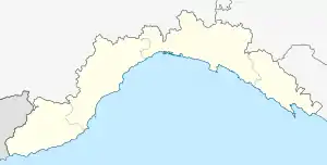 Borzonasca Borzonasca (Liguria) | |
| Coordinates: 44°25′N 9°23′E / 44.417°N 9.383°E | |
| Country | Italy |
| Region | Liguria |
| Metropolitan city | Genoa (GE) |
| Frazioni | Montemoggio, Belpiano, Temossi, Brizzolara, Sopralacroce, Levaggi, Caregli, Borzone, Giaiette, Acero, Gazzolo, Barca di Gazzolo |
| Area | |
| • Total | 80.51 km2 (31.09 sq mi) |
| Elevation | 167 m (548 ft) |
| Population (30 April 2017)[2] | |
| • Total | 2,072 |
| • Density | 26/km2 (67/sq mi) |
| Demonym | Borzonaschini |
| Time zone | UTC+1 (CET) |
| • Summer (DST) | UTC+2 (CEST) |
| Postal code | 16041 |
| Dialing code | 0185 |
| Patron saint | Exaltation of the Holy Cross |
| Saint day | September 14 |
| Website | Official website |
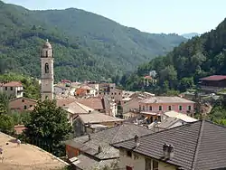
Borzonasca is a comune (municipality) in the Metropolitan City of Genoa in the Italian region Liguria, located about 35 km (22 mi) east of Genoa.
Borzonasca borders the following municipalities: Mezzanego, Ne, Rezzoaglio, San Colombano Certénoli, Santo Stefano d'Aveto, Tornolo, and Varese Ligure.
Borzonasca is part of the Aveto Natural Regional Park.
Main sights
- Church of St. Bartholomew (1628)
- Oratory of Sts. Philip and James (1554)
- Abbey of Borzone
- Abbey of St. Andrew, founded in 1184
Twinnings
References
- ↑ "Superficie di Comuni Province e Regioni italiane al 9 ottobre 2011". Italian National Institute of Statistics. Retrieved 16 March 2019.
- ↑ All demographics and other statistics: Italian statistical institute Istat.
External links
- Official website (in Italian)
This article is issued from Wikipedia. The text is licensed under Creative Commons - Attribution - Sharealike. Additional terms may apply for the media files.