Bowman | |
|---|---|
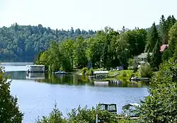 Reservoir l'Escalier | |
 Location within Papineau RCM | |
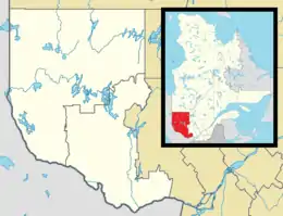 Bowman Location in western Quebec | |
| Coordinates: 45°55′N 75°40′W / 45.917°N 75.667°W[1] | |
| Country | Canada |
| Province | Quebec |
| Region | Outaouais |
| RCM | Papineau |
| Constituted | June 27, 1913 |
| Government | |
| • Mayor | Michel David |
| • Federal riding | Argenteuil—Papineau—Mirabel |
| • Prov. riding | Papineau |
| Area | |
| • Total | 164.40 km2 (63.48 sq mi) |
| • Land | 129.30 km2 (49.92 sq mi) |
| Population (2016)[3] | |
| • Total | 658 |
| • Density | 5.1/km2 (13/sq mi) |
| • Pop 2011-2016 | |
| • Dwellings | 546 |
| Time zone | UTC−5 (EST) |
| • Summer (DST) | UTC−4 (EDT) |
| Postal code(s) | |
| Area code | 819 |
| Highways | |
| Website | www |
Bowman is a village and municipality in the Outaouais region of Quebec, Canada. It is located in the Laurentian Hills, 72 kilometres (45 mi) north-east of Gatineau.
Geography
The municipality is bordered to the east by the Du Lièvre River and by Whitefish Lake (lac du Poisson Blanc) in the north-west. Its terrain is characterized by several deep lakes (including Reservoir l'Escalier) in a hilly terrain with altitudes between 200 meters (660 ft) and 430 meters (1,410 ft).[4]
History
Bowman Township was formed in 1861 and named after one of the first inhabitants of this place, Baxter Bowman, who operated a sawmill at Dufferin Chutes in Buckingham and was owner of a large tract of forest in the Outaouais in the late nineteenth century.[1][4]
On 1 January 1885, Bowman was combined with Villeneuve Township to form the United Township Municipality of Bowman-et-Villeneuve. In 1913, the Township Municipality of Bowman was formed when the two townships separated (Villeneuve was renamed to Val-des-Bois in 1958), and in 1954, its statutes were amended again to become the Municipality of Bowman.[1]
Bowman was affected by the 2010 Central Canada earthquake and suffered some damage to a 50 metre wide area of land near a bridge.[5] Traffic on Route 307 was diverted while Transport Canada assessed the damage. There were no fatalities.
Demographics
| 2021 | 2016 | 2011 | |
|---|---|---|---|
| Population | 667 (+1.4% from 2016) | 658 (-2.8% from 2011) | 677 (0.1% from 2006) |
| Land area | 126.40 km2 (48.80 sq mi) | 129.30 km2 (49.92 sq mi) | 129.75 km2 (50.10 sq mi) |
| Population density | 5.3/km2 (14/sq mi) | 5.1/km2 (13/sq mi) | 5.2/km2 (13/sq mi) |
| Median age | 59.6 (M: 60.0, F: 59.2) | 56.4 (M: 51.8, F: 50.5) | 51.9 (M: 52.0, F: 51.8) |
| Private dwellings | 546 (total) 335 (occupied) | 546 (total) | 527 (total) |
| Median household income | $63,600 | $48,768 | $54,637 |
| Year | Pop. | ±% |
|---|---|---|
| 1986 | 405 | — |
| 1991 | 481 | +18.8% |
| 1996 | 516 | +7.3% |
| 2001 | 563 | +9.1% |
| 2006 | 676 | +20.1% |
| 2011 | 677 | +0.1% |
| 2016 | 658 | −2.8% |
| Population amounts are not adjusted for boundary changes. Source: Statistics Canada | ||
Mother tongue:[3]
- English as first language: 9.8%
- French as first language: 88.6%
- English and French as first language: 0.8%
- Other as first language: 1.5%
Local government
List of former mayors:
- Roger Madore (2005–2009)
- Michel David (2009-2017)
- Pierre Labonté (2017–present)
See also
References
- 1 2 3 "Banque de noms de lieux du Québec: Reference number 7930". toponymie.gouv.qc.ca (in French). Commission de toponymie du Québec.
- 1 2 "Répertoire des municipalités: Geographic code 80145". www.mamh.gouv.qc.ca (in French). Ministère des Affaires municipales et de l'Habitation.
- 1 2 3 "Bowman, Quebec (Code 2480145) Census Profile". 2016 census. Government of Canada - Statistics Canada.
- 1 2 "Bowman (canton)" (in French). Commission de toponymie du Québec. Retrieved 2008-10-07.
- ↑ "5.6 magnitude earthquake rocks Toronto, Ottawa and Montreal". Archived from the original on 2010-06-25. Retrieved 2010-06-23.
- ↑ "2021 Community Profiles". 2021 Canadian Census. Statistics Canada. February 4, 2022. Retrieved 2023-10-19.
- ↑ "2016 Community Profiles". 2016 Canadian Census. Statistics Canada. August 12, 2021. Retrieved 2020-01-22.
- ↑ "2011 Community Profiles". 2011 Canadian Census. Statistics Canada. March 21, 2019. Retrieved 2020-01-22.
- ↑ "2006 Community Profiles". 2006 Canadian Census. Statistics Canada. August 20, 2019.
- ↑ "2001 Community Profiles". 2001 Canadian Census. Statistics Canada. July 18, 2021.
Places adjacent to Bowman, Quebec | |
|---|---|
| Cities | |
|---|---|
| Municipalities | |
| Townships | |
| |